IMAGES TAKEN NEAR TO
Norton Road, NEWHAVEN, BN9 0FN
Introduction
This page details the photographs taken nearby to Norton Road, BN9 0FN by members of the Geograph project.
The Geograph project started in 2005 with the aim of publishing, organising and preserving representative images for every square kilometre of Great Britain, Ireland and the Isle of Man.

There are currently over 7.5m images from over14,400 individuals and you can help contribute to the project by visiting https://www.geograph.org.uk
Image Map
Images are licensed for reuse under creativecommons.org/licenses/by-sa/2.0
Notes
- Clicking on the map will re-center to the selected point.
- The higher the marker number, the further away the image location is from the centre of the postcode.
Image Listing (135 Images Found)
Images are licensed for reuse under creativecommons.org/licenses/by-sa/2.0
Image
Details
Distance
1
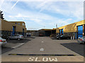
Brightwell Industrial Estate
Located on Norton Road next to Bevan Funnell.
Image: © Simon Carey
Taken: 23 Aug 2012
0.01 miles
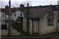
2
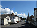
Norton Road
Small side street off Clifton Road that is the main access route for those living on Norton Terrace and Eastbridge Road.
Image: © Simon Carey
Taken: 26 Aug 2012
0.03 miles
3
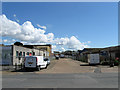
Beach Close
Viewed from the junction with Beach Road. It is currently an access route for a number of factories and workshops that ends at the entrance of Bevan Funnell. However, if I have read the plans for the ASDA development correctly this could well be utilised as the new access road for the ferry terminal.
Image: © Simon Carey
Taken: 26 Aug 2012
0.04 miles
4
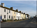
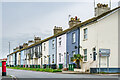
Beach Road
A terrace of cottages on Beach Road dating from the late 19th century and very much a feature on the east side of the river where there is a mixture of residential, factories and businesses.
Image: © Simon Carey
Taken: 23 Aug 2012
0.04 miles
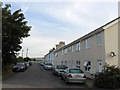
5
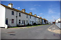
Beach Road
Mainly late 19th Century terraced housing on Beach Road, first marked on the 1899 25 inch map. However the section of four houses left of centre is more recent, built in the c.1980s, replacing a group of three houses that originally projected in front of the main terrace.
Image: © Ian Capper
Taken: 21 May 2024
0.05 miles
6
Terraced houses, Newhaven
On Railway Road.
Image: © Robin Webster
Taken: 10 Aug 2007
0.05 miles
8
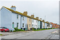
Beach Road
Mainly late 19th Century terraced housing on Beach Road, first marked on the 1899 25 inch map. However the section of four houses towards the far end of the terrace is more recent, built in the c.1980s, replacing a group of three houses that originally projected in front of the main terrace. In the background is the Clifton Road development of 74 apartments, completed in c.2023.
Image: © Ian Capper
Taken: 21 May 2024
0.05 miles
10
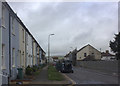
Transit Road
The terrace here backs onto the terrace in this image, Image, and dates from the same period.
Image: © Simon Carey
Taken: 23 Aug 2012
0.07 miles