IMAGES TAKEN NEAR TO
Laughton Road, LEWES, BN8 5UT
Introduction
This page details the photographs taken nearby to Laughton Road, BN8 5UT by members of the Geograph project.
The Geograph project started in 2005 with the aim of publishing, organising and preserving representative images for every square kilometre of Great Britain, Ireland and the Isle of Man.

There are currently over 7.5m images from over14,400 individuals and you can help contribute to the project by visiting https://www.geograph.org.uk
Image Map
Images are licensed for reuse under creativecommons.org/licenses/by-sa/2.0
Notes
- Clicking on the map will re-center to the selected point.
- The higher the marker number, the further away the image location is from the centre of the postcode.
Image Listing (22 Images Found)
Images are licensed for reuse under creativecommons.org/licenses/by-sa/2.0
Image
Details
Distance
1

Hartley Field
The name of the field according to the 1839 tithe map. Formerly part of The Broyle, a medieval deer park and common, that was enclosed in 1767. Part of the field has now been built upon leaving this small remnant between Upper Well Cottage and Heron House. The South Downs provide the backdrop.
Image: © Simon Carey
Taken: 2 Aug 2009
0.05 miles
2
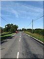
Laughton Road
The B2124 which links Ringmer to the A22 near Holmes Hill. Another post enclosure road that runs in a virtually straight line between the junction of the B2192 and the parish boundary beyond Broyle Place.
Image: © Simon Carey
Taken: 2 Aug 2009
0.08 miles
3
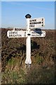
Old Direction Sign - Signpost by the B2124, Laughton Road
Black iron cap finial - 3 arms; East Sussex wood with number by the B2124, in parish of Ringmer (Lewes District), B2124 Laughton Road, on verge opposite junction of Moor Lane with the B2124.
Surveyed
Milestone Society National ID: SX_TQ4712
Image: © Milestone Society
Taken: Unknown
0.09 miles
4

Road Field
The name of the field according to the 1839 tithe map. Formerly part of The Broyle, a medieval deer park and common, that was enclosed in 1767. The building on the left is Heron House formerly the Railway Inn.
Image: © Simon Carey
Taken: 2 Aug 2009
0.09 miles
5

Moorheap
The name of the field according to the 1839 tithe map. Formerly part of The Broyle, a medieval deer park and common, that was enclosed in 1767. Viewed from an opening off Moor Lane where the grid line runs down the eastern side of the road.
Image: © Simon Carey
Taken: 2 Aug 2009
0.09 miles
6

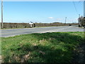
Field off Moors Lane
Looking towards Downsfield Farm.
Image: © Oast House Archive
Taken: 16 Oct 2010
0.10 miles
7
Moor Lane
A minor road that begins near Glyndebourne and reaches its northern junction on the B2124. The building on the right is Heron House a former pub called the Railway Inn that opened in the 1840s and was still marked on a 1969 map as inn though I have no idea when it closed. The name does not derive from a nearby railway inn as there wasn't one within a five mile radius but probably came from those that were employed to build the lines north of Lewes many of whom came from the Ringmer area. The building itself is in TQ4712 as the grid line runs down the eastern side of the lane.
Image: © Simon Carey
Taken: 2 Aug 2009
0.10 miles
8
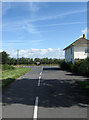
Road signpost on the B2124
The road on the right is Moor lane. Next to the signpost is a footpath marker which runs east to Broyle Place.
Image: © Dave Spicer
Taken: 19 Mar 2011
0.11 miles

10

Deer Pen
The name of the field according to the 1839 tithe map. Formerly part of The Broyle, a medieval deer park and common, that was enclosed in 1767. Viewed from the footpath that links Shortgate to the B2124.
Image: © Simon Carey
Taken: 2 Aug 2009
0.14 miles