IMAGES TAKEN NEAR TO
Lewes Road, LEWES, BN8 5QD
Introduction
This page details the photographs taken nearby to Lewes Road, BN8 5QD by members of the Geograph project.
The Geograph project started in 2005 with the aim of publishing, organising and preserving representative images for every square kilometre of Great Britain, Ireland and the Isle of Man.

There are currently over 7.5m images from over14,400 individuals and you can help contribute to the project by visiting https://www.geograph.org.uk
Image Map
Images are licensed for reuse under creativecommons.org/licenses/by-sa/2.0
Notes
- Clicking on the map will re-center to the selected point.
- The higher the marker number, the further away the image location is from the centre of the postcode.
Image Listing (69 Images Found)
Images are licensed for reuse under creativecommons.org/licenses/by-sa/2.0
Image
Details
Distance
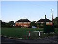
1
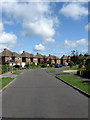
Shepherds Way
Housing estate built in the 1950s consisting of semi-detached houses and bungalows.
Image: © Simon Carey
Taken: 25 Jul 2009
0.06 miles
2
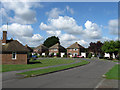
Shepherds Way
Housing estate built during the 1950s consisting of a mixture of semi-detached houses and bungalows.
Image: © Simon Carey
Taken: 25 Jul 2009
0.08 miles
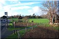
4
Crockendale Field
The name given on the 1839 tithe map and a reminder of the former medieval potteries which operated around the village. Now a cricket field with the houses of Green Close and Bishop's Close beyond the hedge.
Image: © Simon Carey
Taken: 2 Aug 2009
0.08 miles
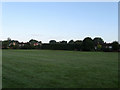
5
Green Close
Small cul-de-sac off Bishop's Lane based around a small green.
Image: © Simon Carey
Taken: 2 Aug 2009
0.08 miles
6
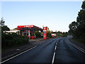
Busy Bee Garage, Lewes Road
On the B2192 near the centre of the village.
Image: © Simon Carey
Taken: 2 Aug 2009
0.08 miles
7
Shepherds Close
Small cul-de-sac off Shepherds Way whose houses and bungalows were built in the 1950s.
Image: © Simon Carey
Taken: 25 Jul 2009
0.10 miles
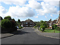
8
St Anthony's
Small modern housing off Harrisons Lane the design of which suggests that perhaps the builders over ordered the roofing tiles in relation to house bricks or perhaps it was cheaper to do it that way. Viewed from Great Paddocks.
Image: © Simon Carey
Taken: 25 Jul 2009
0.10 miles
9
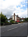
Cheyney House, Lewes Road
Dating from the early 19th century and named after the Cheyney Charity Almshouses the former name of the white cottages beyond now shortened to The Almshouses.
Image: © Simon Carey
Taken: 2 Aug 2009
0.11 miles
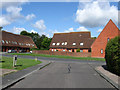
10
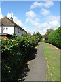
Shepherds Way
The houses on the left of the footpath are numbered for that road but are located on a footpath linking Shepherds Way with Fairlight Field.
Image: © Simon Carey
Taken: 25 Jul 2009
0.11 miles