IMAGES TAKEN NEAR TO
Bishops Close, LEWES, BN8 5LE
Introduction
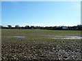
This page details the photographs taken nearby to Bishops Close, BN8 5LE by members of the Geograph project.
The Geograph project started in 2005 with the aim of publishing, organising and preserving representative images for every square kilometre of Great Britain, Ireland and the Isle of Man.

There are currently over 7.5m images from over14,400 individuals and you can help contribute to the project by visiting https://www.geograph.org.uk
Image Map
Images are licensed for reuse under creativecommons.org/licenses/by-sa/2.0
Notes
- Clicking on the map will re-center to the selected point.
- The higher the marker number, the further away the image location is from the centre of the postcode.
Image Listing (62 Images Found)
Images are licensed for reuse under creativecommons.org/licenses/by-sa/2.0
Image
Details
Distance
1
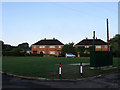
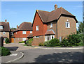
Green Close
Small cul-de-sac off Bishop's Lane based around a small green.
Image: © Simon Carey
Taken: 2 Aug 2009
0.03 miles
2
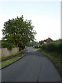
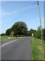
Bishop's Lane
Small rural lane that provides the northern boundary to the built up area of Ringmer. It links Lewes Road and Norlington Lane.
Image: © Simon Carey
Taken: 2 Aug 2009
0.04 miles
3
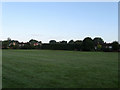
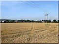
Crockendale Field
The name given on the 1839 tithe map and a reminder of the former medieval potteries which operated around the village. Now a cricket field with the houses of Green Close and Bishop's Close beyond the hedge.
Image: © Simon Carey
Taken: 2 Aug 2009
0.05 miles
4
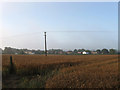
Kiln Field
The name given to the field on the 1839 tithe map and a reminder of the medieval pottery industry that once operated in Ringmer. The house on the left is Trinity Fields whilst houses in Bishop's Lane and Green Close form the northern boundary of the village. A slight mist is still in the air just under an hour after sunrise.
Image: © Simon Carey
Taken: 2 Aug 2009
0.06 miles
5
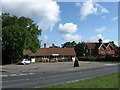
Houses on the northern fringe of Ringmer
Ringmer comes from the medieval name Ring Pool. Although there is no evidence now of a pool, the area was covered with swamps and marshland.
Image: © Dave Spicer
Taken: 19 Mar 2011
0.06 miles
6
Tile Kiln
Small cul-de-sac located off the access road to Diplocks Industrial Estate. Named after the medieval potters whose kilns produced pottery from the clay of the local earth.
Image: © Simon Carey
Taken: 8 Aug 2009
0.08 miles
7
Kiln Field
The name given to the field according to the 1839 tithe map. Also a reminder of the middle pottery industry that operated in Ringmer making use of the clay to produce glazed jugs. The buildings of Diplocks Industrial Estate are on the right whilst those lining Bishop's Lane are to the left. Malling Hill provides the backdrop.
Image: © Simon Carey
Taken: 8 Aug 2009
0.10 miles
8
Old Forge Pine, Lewes Road
Pine furniture shop located in the former village blacksmith building on the corner of the B2192 and Bishop's Lane.
Image: © Simon Carey
Taken: 25 Jul 2009
0.11 miles
9
Bishop's Lane
The junction with North Road is on the left whilst the northern edge of the village green is beyond. The lane links Lewes Road, the B2192, with Norlington Lane.
Image: © Simon Carey
Taken: 8 Aug 2009
0.12 miles
10
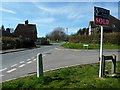
Bishops Lane heading west to the village green
Image: © Dave Spicer
Taken: 19 Mar 2011
0.12 miles