IMAGES TAKEN NEAR TO
Lewes Road, LEWES, BN8 5EY
Introduction
This page details the photographs taken nearby to Lewes Road, BN8 5EY by members of the Geograph project.
The Geograph project started in 2005 with the aim of publishing, organising and preserving representative images for every square kilometre of Great Britain, Ireland and the Isle of Man.

There are currently over 7.5m images from over14,400 individuals and you can help contribute to the project by visiting https://www.geograph.org.uk
Image Map
Images are licensed for reuse under creativecommons.org/licenses/by-sa/2.0
Notes
- Clicking on the map will re-center to the selected point.
- The higher the marker number, the further away the image location is from the centre of the postcode.
Image Listing (25 Images Found)
Images are licensed for reuse under creativecommons.org/licenses/by-sa/2.0
Image
Details
Distance
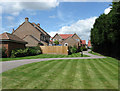
3
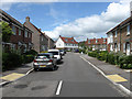
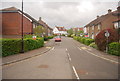
The Forges
Recently completed housing estate built on a field called Forge Field in the 1839 tithe map. There is a small green at the junction with Craig Meadows.
Image: © Simon Carey
Taken: 2 Aug 2009
0.14 miles
4
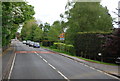
Sadlers Way
Part of an estate built in the 1980s to complete the infilling of the village bounded by New Road, Lewes Road and Gote Lane.
Image: © Simon Carey
Taken: 2 Aug 2009
0.16 miles
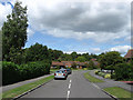
5
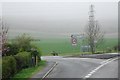
New Road
The road from Glynde and Glyndebourne heads towards its northern junction with Lewes Road, the B2192. The road forms the western edge of the village of Ringmer.
Image: © Simon Carey
Taken: 2 Aug 2009
0.17 miles
6
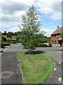
Mill View
Part of the Sadlers Way housing estate built in the 1980s. Viewed from the footpath to Gote Lane.
Image: © Simon Carey
Taken: 2 Aug 2009
0.17 miles
7
The Forges
A new housing estate built on a field called Forge Field in the 1839 tithe map. Viewed from Lewes Road with a footpath to houses in Craig Meadows.
Image: © Simon Carey
Taken: 2 Aug 2009
0.17 miles
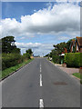
8
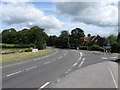
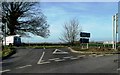
Lewes Road
The B2192 enters the western edge of the village of Ringmer. The minor route to the right is New Road which those wishing to head for Glyndebourne Opera House and the village of Glynde should take.
Image: © Simon Carey
Taken: 2 Aug 2009
0.17 miles