IMAGES TAKEN NEAR TO
Dallas Lane, LEWES, BN8 5DZ
Introduction
This page details the photographs taken nearby to Dallas Lane, BN8 5DZ by members of the Geograph project.
The Geograph project started in 2005 with the aim of publishing, organising and preserving representative images for every square kilometre of Great Britain, Ireland and the Isle of Man.

There are currently over 7.5m images from over14,400 individuals and you can help contribute to the project by visiting https://www.geograph.org.uk
Image Map
Images are licensed for reuse under creativecommons.org/licenses/by-sa/2.0
Notes
- Clicking on the map will re-center to the selected point.
- The higher the marker number, the further away the image location is from the centre of the postcode.
Image Listing (31 Images Found)
Images are licensed for reuse under creativecommons.org/licenses/by-sa/2.0
Image
Details
Distance
1
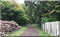
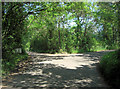
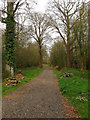
Dallas Lane
Dallas Lane with a woodpile beside the footpath.
Image: © Chris Thomas-Atkin
Taken: 15 Oct 2017
0.01 miles
2
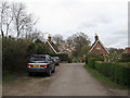
Lodges, Dallas Lane
Built around the mid 19th century to serve the carriage road to Sutton Hall. South Lodge is to the left, Coachmans Lodge to the right.
Image: © Simon Carey
Taken: 3 Apr 2011
0.02 miles
3
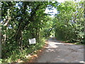
Dallas Lane, near Barcombe Cross
Dallas Lane is a private road leading to a small number of houses in East Sussex countryside. The road is a public right of way as a bridleway, indicated by the wooden signpost to the left of the image.
Image: © Malc McDonald
Taken: 29 Aug 2022
0.05 miles
4
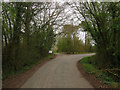
Dallas Lane
Originally the lane continued northwards but is now a private road and track, the public road turning sharply right to become Anchor Lane.
Image: © Simon Carey
Taken: 3 Apr 2011
0.05 miles
5
Dallas Lane turns the corner to become Anchor Lane
Image: © Stuart Logan
Taken: 27 May 2012
0.06 miles
6
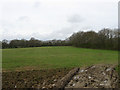
The Commons
The name of the field according to Barcombe's 1839 tithe map that was once part of Whitehoad Common that was enclosed in the 16th century. The hedgerow to the right marks the course of a bridleway that links Dallas Lane to Mount Pleasant.
Image: © Simon Carey
Taken: 3 Apr 2011
0.07 miles
7
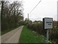
Anchor Lane
Looking westwards towards the junction with Dallas Lane. All of the 'passing place' signs between here and the Anchor Inn have had the P removed though only this one has further amendments to place.
Image: © Simon Carey
Taken: 3 Apr 2011
0.07 miles
8
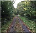
Dallas Lane
Heading North on Dallas Lane towards Burtenshaw’s Wood.
Image: © Chris Thomas-Atkin
Taken: 15 Oct 2017
0.08 miles
9
Dallas Lane
Originally known as Dollicks Lane in the 17th century the word has been corrupted to the current appellation over the intervening centuries. The lane itself originally ran from Clays Corner to Longford Farm but was diverted in the 19th century to become a carriage road for the newly built Sutton Hall whose descendants still own large tracts of land here. A footpath follows the track as far as the River Ouse to the north.
Image: © Simon Carey
Taken: 3 Apr 2011
0.08 miles
10
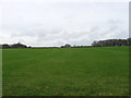
Third Foot Field (1)
The name of the field according to Barcombe's 1839 tithe map viewed from Dallas Lane. Judging by aerial images the gap in the hedge in the distance is to accommodate a landing strip.
Image: © Simon Carey
Taken: 3 Apr 2011
0.10 miles