IMAGES TAKEN NEAR TO
Boast Lane, LEWES, BN8 5DY
Introduction
This page details the photographs taken nearby to Boast Lane, BN8 5DY by members of the Geograph project.
The Geograph project started in 2005 with the aim of publishing, organising and preserving representative images for every square kilometre of Great Britain, Ireland and the Isle of Man.

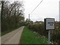
There are currently over 7.5m images from over14,400 individuals and you can help contribute to the project by visiting https://www.geograph.org.uk
Image Map
Images are licensed for reuse under creativecommons.org/licenses/by-sa/2.0
Notes
- Clicking on the map will re-center to the selected point.
- The higher the marker number, the further away the image location is from the centre of the postcode.
Image Listing (24 Images Found)
Images are licensed for reuse under creativecommons.org/licenses/by-sa/2.0
Image
Details
Distance
1

The Hawkins
The name of the field according to the 1839 tithe map. Elm Cottages are to the right.
Image: © Simon Carey
Taken: 6 Dec 2009
0.07 miles
2

Fields near to Boast Lane
Fields leading away from Boast Lane over which a public footpath passes but is not evident due to recent ploughing.
Image: © Chris Thomas-Atkin
Taken: 15 Oct 2017
0.08 miles
3

Church Field
The name of this section of the field according to the 1839 tithe map that has now been extended to Dallas Lane to include Cobnets, Three Acre Field and Old House Field.
Image: © Simon Carey
Taken: 6 Dec 2009
0.08 miles
4

Fortified Barn, Banks Farm
I believe this is a 19th century folly rather than an ancient building converted into a barn.
Image: © Simon Carey
Taken: 6 Dec 2009
0.10 miles
5

Lower Brook
The name of the field according to the 1839 tithe map. The homemade sign makes sure no walkers take the wrong turning. The trees on the left mark the course of Bevern Stream.
Image: © Simon Carey
Taken: 6 Dec 2009
0.10 miles
6

Postbox, Dallas Lane, Mount Pleasant, East Sussex
Image: © nick macneill
Taken: 14 Mar 2012
0.12 miles
7

Clays Corner
The point where Boast Lane in the foreground forms a junction with Dallas Lane to the left. A private drive to Banks Farm heads off to the right which is still a public footpath. The dwelling is Boast Cottage which dates back to the 18th century and was probably a replacement for an earlier building.
Image: © Simon Carey
Taken: 3 Apr 2011
0.12 miles
8

Holes Wish
The name of the field according to the 1839 tithe map. The fortified barn of Banks Farm can be seen to the right.
Image: © Simon Carey
Taken: 6 Dec 2009
0.13 miles
9
Anchor Lane
Looking westwards towards the junction with Dallas Lane. All of the 'passing place' signs between here and the Anchor Inn have had the P removed though only this one has further amendments to place.
Image: © Simon Carey
Taken: 3 Apr 2011
0.15 miles
10

Barns, Scufflings Farm
Lying between Image and the new farmhouse to the west. The current set of barns replaced a much older yard.
Image: © Simon Carey
Taken: 3 Apr 2011
0.17 miles