IMAGES TAKEN NEAR TO
Cockfield Lane, LEWES, BN8 4RP
Introduction
This page details the photographs taken nearby to Cockfield Lane, BN8 4RP by members of the Geograph project.
The Geograph project started in 2005 with the aim of publishing, organising and preserving representative images for every square kilometre of Great Britain, Ireland and the Isle of Man.

There are currently over 7.5m images from over14,400 individuals and you can help contribute to the project by visiting https://www.geograph.org.uk
Image Map
Images are licensed for reuse under creativecommons.org/licenses/by-sa/2.0
Notes
- Clicking on the map will re-center to the selected point.
- The higher the marker number, the further away the image location is from the centre of the postcode.
Image Listing (15 Images Found)
Images are licensed for reuse under creativecommons.org/licenses/by-sa/2.0
Image
Details
Distance
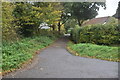
1

Ridgeland Farm
Looking from Cockfield Lane.
Image: © Robin Webster
Taken: 14 Jan 2007
0.05 miles
2

Power line by old railway line
The Lewes - East Grinstead line is the line of bushes and trees to the left of the power line.
Image: © Robin Webster
Taken: 14 Jan 2007
0.20 miles
3

Approaching Cockfield Bridge
The footbridge on Cockfield Lane (Path) which crosses a small stream.
Image: © Chris Thomas-Atkin
Taken: 15 Oct 2017
0.23 miles
4

Cockfield Lane crosses the Longford Stream
A public bridleway.
Image: © Robin Webster
Taken: 14 Jan 2007
0.23 miles
5

Cockfield Bridge
Although the Ordnance Survey call this a footbridge, Cockfield Lane which crosses it is a bridleway, so the bridge is particularly strong with a steel under-structure to safely carry horses.
Image: © Robin Webster
Taken: 14 Jan 2007
0.23 miles
6

Cockfield Bridge
Cockfield Lane is a Path and at this point a footbridge crosses a small stream.
Image: © Chris Thomas-Atkin
Taken: 15 Oct 2017
0.23 miles
7

Cockfield Lane crosses the Longford Stream
A public bridleway.
Image: © Robin Webster
Taken: 14 Jan 2007
0.23 miles
9

Nine Acres
The name of the field according to the 1838 tithe map. Pocketts Wood is at the bottom of the slope.
Image: © Simon Carey
Taken: 26 Dec 2010
0.24 miles
10

Cockfield Bridge
This is the new footbridge, replacing the older steel reinforced one in about 2011/12 I think.
Image: © Martin Horsfall
Taken: 11 Dec 2013
0.24 miles