IMAGES TAKEN NEAR TO
Pouchlands Drive, LEWES, BN8 4RN
Introduction
This page details the photographs taken nearby to Pouchlands Drive, BN8 4RN by members of the Geograph project.
The Geograph project started in 2005 with the aim of publishing, organising and preserving representative images for every square kilometre of Great Britain, Ireland and the Isle of Man.

There are currently over 7.5m images from over14,400 individuals and you can help contribute to the project by visiting https://www.geograph.org.uk
Image Map
Images are licensed for reuse under creativecommons.org/licenses/by-sa/2.0
Notes
- Clicking on the map will re-center to the selected point.
- The higher the marker number, the further away the image location is from the centre of the postcode.
Image Listing (33 Images Found)
Images are licensed for reuse under creativecommons.org/licenses/by-sa/2.0
Image
Details
Distance
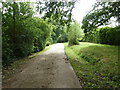
1

A mobility scooter enters Pouchlands Drive, South Chailey
Image: © nick macneill
Taken: 9 Dec 2011
0.03 miles
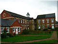
2
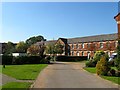
Former Infirmary, Chailey Union Workhouse
Built in 1873 to replace three former workhouses based in North Chailey, Ringmer and Ditchling. This block lies to the west of the former main block which is out of shot to the left. The workhouse became the Lewes Union in 1898 and Lewes Institution in 1930. It was converted into a hospital, Pouchlands, in 1948 and closed at the end of the 1980s. It was converted into residential use in 1991 with this section now in a cul de sac called Shepherds Way.
Image: © Simon Carey
Taken: 2 Oct 2015
0.04 miles
3
Honeypot Lane
Entering the western edge of South Chailey though this is still part of East Chiltington parish here. Once the road crosses into Chailey parish it becomes Mill Lane.
Image: © Simon Carey
Taken: 30 Oct 2009
0.05 miles
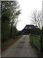
4
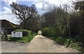
Track to Yokehurst
Looking along the track to Yokehurst with the local surgery off to the left.
Image: © Chris Thomas-Atkin
Taken: 16 Apr 2018
0.06 miles
5
Concrete road and bridleway to Yokehurst
Image: © Dave Spicer
Taken: 7 Sep 2011
0.08 miles
6
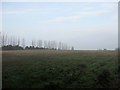
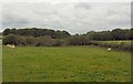
The Toll
The name of the field according to the 1842 tithe map. The early morning fog is still lingering and did so for another hour or so.
Image: © Simon Carey
Taken: 30 Oct 2009
0.09 miles
7
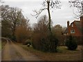
Pouchlands Farmhouse
Dating back to the 17th century the former farmhouse was split into three cottages sometime in the 1960s or 70s but has now reverted back to being one residence.
Image: © Simon Carey
Taken: 2 Jan 2011
0.09 miles
8
Pixie Barn
Converted barn viewed from Honeypot Lane.
Image: © Simon Carey
Taken: 30 Oct 2009
0.10 miles
9
Shepherds Way, South Chailey
Former workhouse buildings now converted into upmarket residences. This view looks south.
Image: © Simon Carey
Taken: 26 Oct 2005
0.11 miles