IMAGES TAKEN NEAR TO
Windyacre, Newick Drive, LEWES, BN8 4PD
Introduction
This page details the photographs taken nearby to Windyacre, Newick Drive, BN8 4PD by members of the Geograph project.
The Geograph project started in 2005 with the aim of publishing, organising and preserving representative images for every square kilometre of Great Britain, Ireland and the Isle of Man.

There are currently over 7.5m images from over14,400 individuals and you can help contribute to the project by visiting https://www.geograph.org.uk
Image Map
Images are licensed for reuse under creativecommons.org/licenses/by-sa/2.0
Notes
- Clicking on the map will re-center to the selected point.
- The higher the marker number, the further away the image location is from the centre of the postcode.
Image Listing (15 Images Found)
Images are licensed for reuse under creativecommons.org/licenses/by-sa/2.0
Image
Details
Distance
5

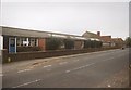
Former Zion Baptist Chapel, Newick
This chapel has been restored into a dwelling.
Image: © Mark Collins
Taken: 15 Nov 2001
0.18 miles
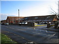
6
Newick School
This is the old primary school building, demolished in 2000. A new school was built on the same site.
Image: © Martin Horsfall
Taken: Unknown
0.19 miles
8
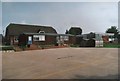
Newick School
The rear of the school. Buildings demolished in 2000 to make way for new school.
Image: © Martin Horsfall
Taken: Unknown
0.20 miles
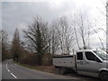
10
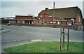
Newick School
This is the old primary school building, demolished in 2000.
Image: © Martin Horsfall
Taken: Unknown
0.20 miles