IMAGES TAKEN NEAR TO
East Chiltington, LEWES, BN7 3QR
Introduction
This page details the photographs taken nearby to BN7 3QR by members of the Geograph project.
The Geograph project started in 2005 with the aim of publishing, organising and preserving representative images for every square kilometre of Great Britain, Ireland and the Isle of Man.

There are currently over 7.5m images from over14,400 individuals and you can help contribute to the project by visiting https://www.geograph.org.uk
Image Map
Images are licensed for reuse under creativecommons.org/licenses/by-sa/2.0
Notes
- Clicking on the map will re-center to the selected point.
- The higher the marker number, the further away the image location is from the centre of the postcode.
Image Listing (21 Images Found)
Images are licensed for reuse under creativecommons.org/licenses/by-sa/2.0
Image
Details
Distance
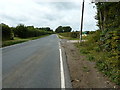
1
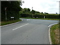
T junction at the end of Honeypot Lane
Novington Lane, from Novington Farm near Plumpton, is on the left and South Road continues north to Wivelsfield Green.
Image: © Dave Spicer
Taken: 7 Sep 2011
0.04 miles
3
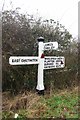
Old Direction Sign - Signpost opposite Honeypot Lane, East Chiltington parish
Black iron cap finial - 3 arms; East Sussex wood by the UC road, in parish of East Chiltington (Lewes District), junction of Novington Lane with South Road and Honeypot Lane, on verge.
Surveyed
Milestone Society National ID: SX_TQ3717
Image: © Milestone Society
Taken: Unknown
0.05 miles
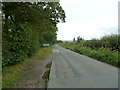
4
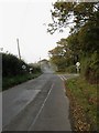
Novington Lane
The northern end of the lane as it meets South Road at the junction with Honeypot Lane. The former heads north to Wivelsfield Green whilst the latter goes east to South Chailey. The road in the distance is partially obscured by smoke from a bonfire.
Image: © Simon Carey
Taken: 30 Oct 2009
0.05 miles
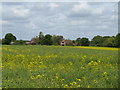
5
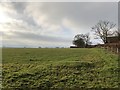
Fields south of Homewoodgate Farm
Passing the farm on the footpath heading towards Plumpton Green.
Image: © Chris Thomas-Atkin
Taken: 29 Dec 2019
0.05 miles
8
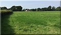
Field beside Honeypot Lane
A view of a field beside Honeypot Lane with a distant view of a house next to the road to Plumpton Green.
Image: © Chris Thomas-Atkin
Taken: 29 Aug 2017
0.12 miles
9
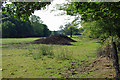
Agricultural heaps
The composition of the heaps is not obvious, but for Geograph purposes they will be classified as manure heaps.
Image: © Robin Webster
Taken: 1 Sep 2010
0.14 miles
10
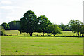
Trees on the fenceline
There is actually a drainage ditch running along the fence here, but it is not obvious from this distance.
Image: © Robin Webster
Taken: 1 Sep 2010
0.14 miles