IMAGES TAKEN NEAR TO
The Street, LEWES, BN7 3QB
Introduction
This page details the photographs taken nearby to The Street, BN7 3QB by members of the Geograph project.
The Geograph project started in 2005 with the aim of publishing, organising and preserving representative images for every square kilometre of Great Britain, Ireland and the Isle of Man.

There are currently over 7.5m images from over14,400 individuals and you can help contribute to the project by visiting https://www.geograph.org.uk
Image Map
Images are licensed for reuse under creativecommons.org/licenses/by-sa/2.0
Notes
- Clicking on the map will re-center to the selected point.
- The higher the marker number, the further away the image location is from the centre of the postcode.
Image Listing (71 Images Found)
Images are licensed for reuse under creativecommons.org/licenses/by-sa/2.0
Image
Details
Distance
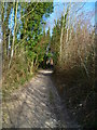
1
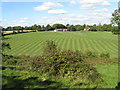
Scarified field at Mill Laine Farm
From bridleway on Offham Hill.
Image: © Dave Spicer
Taken: 25 Sep 2010
0.00 miles
2
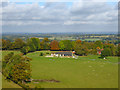
Mill Laine Barns
A residential conversion.
Image: © Robin Webster
Taken: 27 Oct 2016
0.01 miles
3
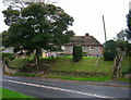
Turnpike Cottages, Offham
On the A275 looking west. The cottages are next to Offham House.
Image: © Simon Carey
Taken: 26 Oct 2005
0.11 miles
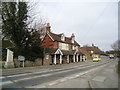
6

Blacksmith's Arms, Offham, East Sussex
The Pub also provides accommodation and is noted for its seafood dishes.
Image: © Kevin Gordon
Taken: 18 Oct 2008
0.16 miles
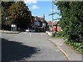
7
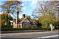
Lodge,Coombe Place
At the entrance from the A275.
Image: © Robin Webster
Taken: 27 Oct 2016
0.17 miles
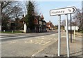
10
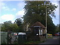
Bus shelter and rear of church, Offham
Image: © David Howard
Taken: 12 Sep 2011
0.17 miles