IMAGES TAKEN NEAR TO
Juggs Road, LEWES, BN7 3PN
Introduction
This page details the photographs taken nearby to Juggs Road, BN7 3PN by members of the Geograph project.
The Geograph project started in 2005 with the aim of publishing, organising and preserving representative images for every square kilometre of Great Britain, Ireland and the Isle of Man.

There are currently over 7.5m images from over14,400 individuals and you can help contribute to the project by visiting https://www.geograph.org.uk
Image Map
Images are licensed for reuse under creativecommons.org/licenses/by-sa/2.0
Notes
- Clicking on the map will re-center to the selected point.
- The higher the marker number, the further away the image location is from the centre of the postcode.
Image Listing (127 Images Found)
Images are licensed for reuse under creativecommons.org/licenses/by-sa/2.0
Image
Details
Distance
1
Greenwich Meridian crossing Kingston Road
This picture was taken standing on the Greenwich meridian looking North. The left half of the image is in the Western Hemisphere and the right is in the Eastern. The meridian passes straight through the middle, see this http://www.riddlerworld.co.uk/meridian/PG0946.htm for an alternate image with the meridian superimposed as a yellow line. The Meridian crosses the Kingston Road and then goes through a large house, now a nursery school.
Image: © steve ridley
Taken: 8 Mar 2011
0.01 miles
2
Greenwich meridian from Juggs lane
This picture was taken standing on the Greenwich meridian looking North. The left half of the image is in the Western Hemisphere and the right is in the Eastern. The meridian passes straight through the middle, see this http://www.riddlerworld.co.uk/meridian/PG0953.htm for an alternate image with the meridian superimposed as a yellow line. The Meridian cuts through trees and private gardens in Lewes. Photo taken from Juggs lane looking north.
Image: © steve ridley
Taken: 8 Mar 2011
0.03 miles
3
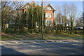
The Coach House, Kingston Road
The old route of Kingston Road goes to the left with a small portion used as a car park for the house and other nearby properties. The new realigned road constructed in 1976 to cross the new Lewes Southern By-Pass heads off to the right.
Image: © Simon Carey
Taken: 8 Feb 2009
0.04 miles
5
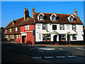
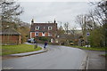
Swan Inn, Lewes
Situated in the southern suburb of Southover the Swan stands at the junction of Southover High Street, Kingston Road (left) and Bell Lane (right). This view looks west and was taken from Southover High Street.
Image: © Simon Carey
Taken: 16 Oct 2005
0.05 miles
6
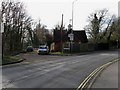
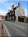
Laundry Cottages, Kingston Road
Opposite side of the road to Image Juggs Road heads off to the right and is the ancient trackway to Brighton that followed the higher ground before ascending the South Downs north of Kingston. Kingston Road was once the A275 to Newhaven but was redesignated the C7 when the former B2109 was upgraded to the A26 to enable all heavy traffic to avoid the narrow streets of Lewes.
Image: © Simon Carey
Taken: 8 Feb 2009
0.05 miles

9
25 Kingston Road
On the road entering into Southover an old suburb of Lewes. The house further up is the Old Forge and dates in part to the 16th century.
Image: © Simon Carey
Taken: 8 Feb 2009
0.06 miles
10

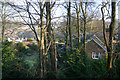
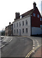
Houses in the Southover district of Lewes
The two newish buildings in centre background are part of County Hall. Juggs Road leads off to the left.
Image: © Dave Spicer
Taken: 14 May 2010
0.07 miles