IMAGES TAKEN NEAR TO
Wellgreen Lane, LEWES, BN7 3NS
Introduction
This page details the photographs taken nearby to Wellgreen Lane, BN7 3NS by members of the Geograph project.
The Geograph project started in 2005 with the aim of publishing, organising and preserving representative images for every square kilometre of Great Britain, Ireland and the Isle of Man.

There are currently over 7.5m images from over14,400 individuals and you can help contribute to the project by visiting https://www.geograph.org.uk
Image Map
Images are licensed for reuse under creativecommons.org/licenses/by-sa/2.0
Notes
- Clicking on the map will re-center to the selected point.
- The higher the marker number, the further away the image location is from the centre of the postcode.
Image Listing (39 Images Found)
Images are licensed for reuse under creativecommons.org/licenses/by-sa/2.0
Image
Details
Distance
2
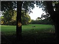
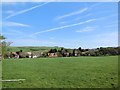
Swanborough Laine (3)
The name of the field according to Kingston's 1843 tithe map that was once one of the three large open fields that surrounded the village from the Saxon period until their enclosure in 1834. This is the eastern end that was landscaped with trees after becoming the grounds of Kingston House during the Edwardian period.
Image: © Simon Carey
Taken: 12 Aug 2012
0.10 miles
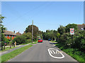
3
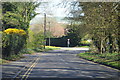
Wellgreen Lane
Approaching junction with Kingston Road.
Image: © J.Hannan-Briggs
Taken: 12 Apr 2015
0.11 miles
4
Wellgreen Lane
The main road through the village of Kingston near Lewes is a bit of a rat run as it allows a connection between the A27 and C7 without having to through Lewes.
Image: © Simon Carey
Taken: 21 Sep 2008
0.12 miles
5
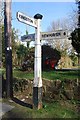
Old Direction Sign - Signpost by Kingston Road, Lewes
Black iron cap finial - 3 arms; East Sussex wood by the UC road, in parish of Kingston near Lewes (Lewes District), Kingston Road, on verge opposite junction of Wellgreen Lane (outside Lewes Garden Centre).
Surveyed
Milestone Society National ID: SX_TQ4008
Image: © Milestone Society
Taken: Unknown
0.12 miles
6
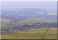
Wellgreen Lane, Kingston near Lewes
Wellgreen Lane is the Road running along the bottom of the view. Spring Barn can be seen in the centre left with Lewes in the distance. Taken from Swanborough Hill.
Image: © Kevin Gordon
Taken: 31 Jan 2009
0.13 miles
7
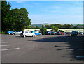
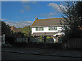
Wyevale Garden Centre, near Kingston
Just off the C7 near to the Kingston turning. A shame it isn't connected to the footpath running past the rear of its premises as it has a small cafe that provides a welcome respite to a few hours walking.
Image: © Simon Carey
Taken: 21 Sep 2008
0.14 miles
8
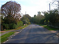
Wellgreen Lane
The lane links the junction of The Street with the C7 Lewes-Newhaven road. Well Green was the old common for Kingston until the enclosure of all the open fields in 1834, the ribbon development along began after the First World War and now runs the entire length to the C7.
Image: © Simon Carey
Taken: 26 Jul 2012
0.14 miles
9
Kingston near Lewes
View from the path from Wellgreen Lane
Image: © Paul Gillett
Taken: 10 Apr 2014
0.14 miles
10
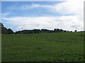
The Latchetts
The name of the field according to Kingston's 1843 tithe map and originally one of three smaller open fields that straddled the Lewes-Newhaven road to the east of the village from Saxon times until enclosure in 1834.
Image: © Simon Carey
Taken: 12 Aug 2012
0.15 miles