IMAGES TAKEN NEAR TO
Mushroom Field, LEWES, BN7 3LE
Introduction
This page details the photographs taken nearby to Mushroom Field, BN7 3LE by members of the Geograph project.
The Geograph project started in 2005 with the aim of publishing, organising and preserving representative images for every square kilometre of Great Britain, Ireland and the Isle of Man.

There are currently over 7.5m images from over14,400 individuals and you can help contribute to the project by visiting https://www.geograph.org.uk
Image Map
Images are licensed for reuse under creativecommons.org/licenses/by-sa/2.0
Notes
- Clicking on the map will re-center to the selected point.
- The higher the marker number, the further away the image location is from the centre of the postcode.
Image Listing (158 Images Found)
Images are licensed for reuse under creativecommons.org/licenses/by-sa/2.0
Image
Details
Distance
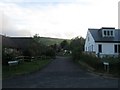
1
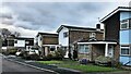
Houses on Mushroom Field
"Mushroom Field" is the name of this road.
Image: © Ian Hawfinch
Taken: 21 Nov 2020
0.01 miles
2
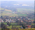
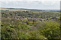
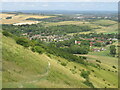
Kingston near Lewes
Taken from the South Downs above the village. The church of St Pancras can be seen in the lower right with Spring Barn, Kingston Road Image centre view. In the distance is Malling Hill with the buildings of Lewes Golf Club at Image between the two white chalk cliffs.
Image: © Kevin Gordon
Taken: 31 Jan 2009
0.02 miles
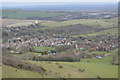
4
Kingston near Lewes
Lewes is in the background.
Image: © N Chadwick
Taken: 7 Apr 2016
0.03 miles
6
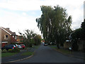
Monckton Way
Part of an estate that was built in the 1960s. Viewed from its junction with Lockett Way.
Image: © Simon Carey
Taken: 12 Aug 2012
0.04 miles
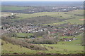
7
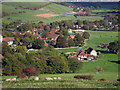
Kingston
Looking over buildings on the Street, from the South Downs.
Image: © Oast House Archive
Taken: 24 Oct 2010
0.04 miles
8
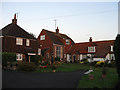
Barn Close
Small cul de sac off The Street built in the 1960s on the site of an old barn. Part of the former farm buildings survive as a converted house behind the building on the right.
Image: © Simon Carey
Taken: 15 Sep 2012
0.05 miles
9
Descending to Kingston
A steep chalk path drops down from the South Downs Way, time to enjoy the views over Kingston village towards the Ashcombe smock-mill and the county town of Lewes.
Image: © David M Clark
Taken: 10 Jul 2023
0.06 miles
10
The Flints
Small cul de sac off Ashcombe Lane built in the 1990s.
Image: © Simon Carey
Taken: 12 Aug 2012
0.06 miles