IMAGES TAKEN NEAR TO
Sun Close, LEWES, BN7 3FA
Introduction
This page details the photographs taken nearby to Sun Close, BN7 3FA by members of the Geograph project.
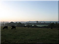
The Geograph project started in 2005 with the aim of publishing, organising and preserving representative images for every square kilometre of Great Britain, Ireland and the Isle of Man.

There are currently over 7.5m images from over14,400 individuals and you can help contribute to the project by visiting https://www.geograph.org.uk
Image Map
Images are licensed for reuse under creativecommons.org/licenses/by-sa/2.0
Notes
- Clicking on the map will re-center to the selected point.
- The higher the marker number, the further away the image location is from the centre of the postcode.
Image Listing (57 Images Found)
Images are licensed for reuse under creativecommons.org/licenses/by-sa/2.0
Image
Details
Distance
1
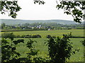
Country scene in the Low Weald
The building in the middle of the photo is the grandstand at Plumpton Racecourse
Image: © Dave Spicer
Taken: 20 May 2009
0.05 miles
2
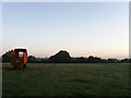
Shop Field
The name of the field according to the 1839 tithe map. It has been enlarged to include North Field which lies out of shot to the east. Taken ten minutes after sunrise with some evidence of a ground frost.
Image: © Simon Carey
Taken: 18 Oct 2009
0.05 miles
3
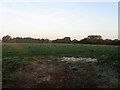
North Field
The name of the field according to the 1839 tithe map that has now been enlarged to include Shop Field to the west.
Image: © Simon Carey
Taken: 18 Oct 2009
0.06 miles
4
Two Acres
The name of the field according to the 1839 tithe map that has now been enlarged to include Middle Field to the east. The field drops down towards Bevern Stream marked by the bushes in the middle distance whilst beyond is King George V Playing Fields which is covered by a ground frost.
Image: © Simon Carey
Taken: 18 Oct 2009
0.10 miles
5
Middle Field
The name of the field according to the 1839 tithe map that has been enlarged to include Two Acres to the west. King George V Playing Fields are beyond covered by a layer of frost, the grandstand of Plumpton Racecourse can just be made out beyond whilst the northern escarpment of the South Downs provides the backdrop. There had been a mist but had lifted soon after sunrise.
Image: © Simon Carey
Taken: 18 Oct 2009
0.10 miles
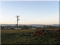
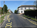
6
North Barnes Lane
A private road and public bridleway that connects Station Road with Novington Lane via North Barnes Farm. This looks back to the junction with the former.
Image: © Simon Carey
Taken: 18 Oct 2009
0.10 miles
7
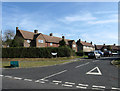
Southdowns
Small cul-de-sac off Station Road which also contains the current village primary school.
Image: © Simon Carey
Taken: 26 Sep 2009
0.11 miles
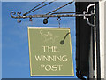
8
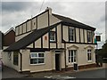
The Winning Post pub, Plumpton
details: http://www.beerintheevening.com/pubs/s/23/23619/Winning_Post/Plumpton_Green
Image: © Paul Gillett
Taken: 16 Sep 2010
0.11 miles
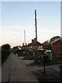
9
The Winning Post, Station Road
One of two pubs in the village of Plumpton Green, The Fountain being about half a mile further up the road. Located on the corner of North Barnes Lane.
Image: © Simon Carey
Taken: 26 Sep 2009
0.12 miles