IMAGES TAKEN NEAR TO
North Barnes Lane, LEWES, BN7 3DU
Introduction
This page details the photographs taken nearby to North Barnes Lane, BN7 3DU by members of the Geograph project.
The Geograph project started in 2005 with the aim of publishing, organising and preserving representative images for every square kilometre of Great Britain, Ireland and the Isle of Man.

There are currently over 7.5m images from over14,400 individuals and you can help contribute to the project by visiting https://www.geograph.org.uk
Image Map
Images are licensed for reuse under creativecommons.org/licenses/by-sa/2.0
Notes
- Clicking on the map will re-center to the selected point.
- The higher the marker number, the further away the image location is from the centre of the postcode.
Image Listing (8 Images Found)
Images are licensed for reuse under creativecommons.org/licenses/by-sa/2.0
Image
Details
Distance
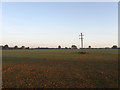
1
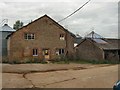
North Barnes Farm
To the East of Plumpton
Image: © Paul Gillett
Taken: 16 Sep 2010
0.06 miles
2
North Barnes Farm
Viewed from North Barnes Lane and receiving the first glow of sun of the day.
Image: © Simon Carey
Taken: 18 Oct 2009
0.06 miles
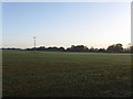
3
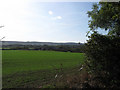
The Spergolds
The name of this section of the field according to the 1842 tithe map that has been enlarged into one big modern field by the amalgamation of five smaller ones. North Barnes Farm can be seen in the distance with the northern escarpment of the South Downs forming the backdrop.
Image: © Simon Carey
Taken: 18 Oct 2009
0.09 miles
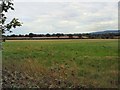
5
Job Field
The name of this section of the field according to the 1842 tithe map. The modern field stretches from near North Barnes Farm to Novington Lane and North Barnes Lane to the footpath to the north and has incorporated what were five smaller fields. All hedgerows and any trees have gone leaving it impossible to discover where the boundaries originally lay. The field is illuminated by the first rays of sunshine of the day.
Image: © Simon Carey
Taken: 18 Oct 2009
0.11 miles
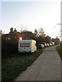
6
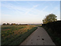
North Barnes Lane
A private road that connects North Barnes Farm to both Novington Lane and Station Road. It is also a public bridleway. North Barnes Farm is hidden by the foliage to the left.
Image: © Simon Carey
Taken: 18 Oct 2009
0.13 miles
7
Lower Mead
The name of this section of the field according to the 1842 tithe map. The modern field stretches from near North Barnes Farm to Novington Lane and North Barnes Lane to the footpath to the north and has incorporated what were five smaller fields. Field Cottage on Novington Lane is visible on the right.
Image: © Simon Carey
Taken: 18 Oct 2009
0.23 miles
8
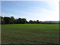
Pond Field
The name of this section of the field according to the 1842 tithe map that has been enlarged into one big modern field by the amalgamation of five smaller ones.
Image: © Simon Carey
Taken: 18 Oct 2009
0.24 miles