IMAGES TAKEN NEAR TO
Novington Lane, LEWES, BN7 3AU
Introduction
This page details the photographs taken nearby to Novington Lane, BN7 3AU by members of the Geograph project.
The Geograph project started in 2005 with the aim of publishing, organising and preserving representative images for every square kilometre of Great Britain, Ireland and the Isle of Man.

There are currently over 7.5m images from over14,400 individuals and you can help contribute to the project by visiting https://www.geograph.org.uk
Image Map
Images are licensed for reuse under creativecommons.org/licenses/by-sa/2.0
Notes
- Clicking on the map will re-center to the selected point.
- The higher the marker number, the further away the image location is from the centre of the postcode.
Image Listing (25 Images Found)
Images are licensed for reuse under creativecommons.org/licenses/by-sa/2.0
Image
Details
Distance
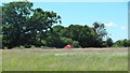
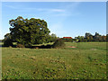
1
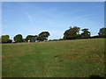
Dial Croft
The name of the field according to the 1842 tithe map. Two cross country runners are busy running along the footpath that heads towards Birchington Farm having taken bearings with me from the crossroads of footpaths that lay where the image was taken from.
Image: © Simon Carey
Taken: 18 Oct 2009
0.07 miles
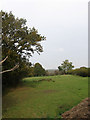
2
Middle Orchard
The name of the field according to the 1844 tithe map that recorded the usage as pasture suggesting a grubbing within living memory. Now a small paddock next to Wootton Farmhouse. The name itself is a reminder of the days when all farms would have a small orchard next to it often for personal rather commercial use.
Image: © Simon Carey
Taken: 30 Oct 2009
0.07 miles
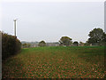
3
Hog Lag
The name of this small field according to the 1844 tithe map that suggests a pasture use for pigs. Now used as a paddock for horses.
Image: © Simon Carey
Taken: 30 Oct 2009
0.07 miles
4
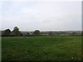
The Lower Orchard
The name of the field according to the 1844 tithe map whose usage then indicated arable use suggesting a grubbing in living memory. Now used as a paddock for horses.
Image: © Simon Carey
Taken: 30 Oct 2009
0.07 miles
5
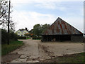
Wootton Farm
The farmhouse may have elements within dating back to the 17th century but has been restored at various intervals over the centuries. The farm itself ceased agricultural production in 2000 and has since diversified by turning the farmhouse into a bed and breakfast and a tithe barn into residential accommodation. The farm is also the centre point of a number of bridleways and footpaths that run converge here.
Image: © Simon Carey
Taken: 30 Oct 2009
0.10 miles
6
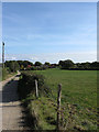
Ashdown Field
The name of the field according to the 1842 tithe map. The drive leads to Birchington Farm, seen in the distance, and Wootton Farm.
Image: © Simon Carey
Taken: 18 Oct 2009
0.11 miles
8
Lower Pells (1)
The name of the field according to the 1842 tithe map. A small dry stream bed runs through the field on the left whilst two footpaths meet at the northern side.
Image: © Simon Carey
Taken: 18 Oct 2009
0.12 miles
9
Lower Pells (2)
Another view of Image this time looking to the north towards The Grange on the right and the roof of barn belonging to Wootton Farm in the centre. A dry stream bed runs left to right in the foreground.
Image: © Simon Carey
Taken: 18 Oct 2009
0.14 miles
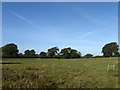
10
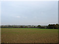
West Field
The name of the field according to the 1842 tithe map. The first rises of the Low Weald are beyond in the distance.
Image: © Simon Carey
Taken: 30 Oct 2009
0.14 miles