IMAGES TAKEN NEAR TO
Plumpton, LEWES, BN7 3AN
Introduction
This page details the photographs taken nearby to BN7 3AN by members of the Geograph project.
The Geograph project started in 2005 with the aim of publishing, organising and preserving representative images for every square kilometre of Great Britain, Ireland and the Isle of Man.

There are currently over 7.5m images from over14,400 individuals and you can help contribute to the project by visiting https://www.geograph.org.uk
Image Map
Images are licensed for reuse under creativecommons.org/licenses/by-sa/2.0
Notes
- Clicking on the map will re-center to the selected point.
- The higher the marker number, the further away the image location is from the centre of the postcode.
Image Listing (26 Images Found)
Images are licensed for reuse under creativecommons.org/licenses/by-sa/2.0
Image
Details
Distance
1
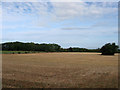
The Ten Acres
The name of the field according to the 1842 tithe map. Odintune Place is located in the trees to the left.
Image: © Simon Carey
Taken: 4 Oct 2009
0.09 miles
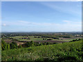
2
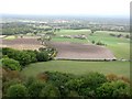
View north from Blackcap
Left of centre field is Newstead Farmhouse, with Warningore Farm behind. Novington Woods are left corner middle distance.
Image: © Peter Whitcomb
Taken: 11 Oct 2009
0.10 miles
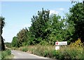
3
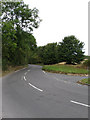
Lewes Road
The B2116 and the junction with Novington Lane. The old droving route continues up the Downs by a footpath out of shot to the left.
Image: © Simon Carey
Taken: 4 Oct 2009
0.11 miles
4
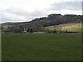
Pastures east of Plumpton
Trees on Blackcap are on the horizon. The B2116 runs left to right at the bottom of the hill.
Image: © Dave Spicer
Taken: 21 Mar 2010
0.11 miles
5
Newstead Farm
On Novington Lane near the junction with Lewes Road, the B2116.
Image: © Simon Carey
Taken: 4 Oct 2009
0.12 miles
6
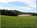
The Kiln Field
The name of the field according to the 1842 tithe map. The wood on the left was the site of the former limekilns where the field got its name.
Image: © Simon Carey
Taken: 4 Oct 2009
0.14 miles
7
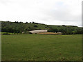
The Knowles
The name of the field according to the 1842 tithe map. Plumpton Plain is on top of the scarp slope of the South Downs.
Image: © Simon Carey
Taken: 4 Oct 2009
0.15 miles
8
The Bars
The name of this section of the field according to the 1842 tithe map that has been enlarged to include Kemps Meadow and The Four Acres to the north, a change that has only occurred in the last thirty years.
Image: © Simon Carey
Taken: 4 Oct 2009
0.15 miles
9
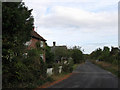
Novington Lane, East Chiltington, East Sussex
Image: © nick macneill
Taken: 31 Aug 2012
0.15 miles
10
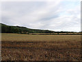
Catlands
The name of the field in the foreground according to the 1842 tithe map. In the distance is Warningore Farm on the left and Warningore Wood to the right with the Weald beyond.
Image: © Simon Carey
Taken: 4 Oct 2009
0.16 miles