IMAGES TAKEN NEAR TO
Plumpton Lane, LEWES, BN7 3AJ
Introduction
This page details the photographs taken nearby to Plumpton Lane, BN7 3AJ by members of the Geograph project.
The Geograph project started in 2005 with the aim of publishing, organising and preserving representative images for every square kilometre of Great Britain, Ireland and the Isle of Man.

There are currently over 7.5m images from over14,400 individuals and you can help contribute to the project by visiting https://www.geograph.org.uk
Image Map
Images are licensed for reuse under creativecommons.org/licenses/by-sa/2.0
Notes
- Clicking on the map will re-center to the selected point.
- The higher the marker number, the further away the image location is from the centre of the postcode.
Image Listing (47 Images Found)
Images are licensed for reuse under creativecommons.org/licenses/by-sa/2.0
Image
Details
Distance
1
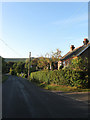
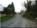
Plumpton Lane
The major north-south road in the parish of Plumpton. The cottages in view are at the northern edge of the village of Plumpton.
Image: © Simon Carey
Taken: 26 Sep 2009
0.02 miles
2
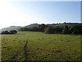
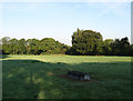
Marl Pit Laine
The name of the field according to the 1839 tithe map. Blackcap can be seen in the distance through the morning haze.
Image: © Simon Carey
Taken: 26 Sep 2009
0.05 miles
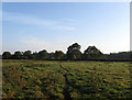
3
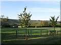
Mill Meadow
The name of the field according to the 1839 tithe map. The northern scarp slope of the South Downs are beyond.
Image: © Simon Carey
Taken: 26 Sep 2009
0.06 miles
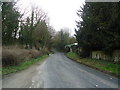
4
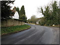
Looking north on Plumpton Lane in Plumpton
Plumpton Lane travels north to Plumpton Green
Image: © Dave Spicer
Taken: 21 Mar 2010
0.07 miles
6
Lower Petlands
The name of the field according to the 1839 tithe map. Viewed from the footpath that links Plumpton Lane with Novington Manor.
Image: © Simon Carey
Taken: 26 Sep 2009
0.08 miles
7
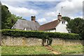
The Eugh
The Eugh is a Grade II listed building on Plumpton Lane. See https://historicengland.org.uk/listing/the-list/list-entry/1238287
Image: © Chris Thomas-Atkin
Taken: 14 Jul 2019
0.09 miles
9
Hay Stack Field
The name of the field according to the 1839 tithe map. Taken from the footpath that links Plumpton Lane to Plumpton College.
Image: © Simon Carey
Taken: 26 Sep 2009
0.09 miles
10
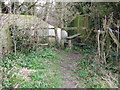
Old stile and squeeze posts at Plumpton
Image: © Dave Spicer
Taken: 21 Mar 2010
0.10 miles