IMAGES TAKEN NEAR TO
Malling Street, LEWES, BN7 2RD
Introduction
This page details the photographs taken nearby to Malling Street, BN7 2RD by members of the Geograph project.
The Geograph project started in 2005 with the aim of publishing, organising and preserving representative images for every square kilometre of Great Britain, Ireland and the Isle of Man.

There are currently over 7.5m images from over14,400 individuals and you can help contribute to the project by visiting https://www.geograph.org.uk
Image Map
Images are licensed for reuse under creativecommons.org/licenses/by-sa/2.0
Notes
- Clicking on the map will re-center to the selected point.
- The higher the marker number, the further away the image location is from the centre of the postcode.
Image Listing (689 Images Found)
Images are licensed for reuse under creativecommons.org/licenses/by-sa/2.0
Image
Details
Distance
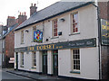
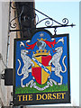
1
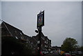
The Dorset sign
The brewery tap for Harveys.
Image: © N Chadwick
Taken: 14 Apr 2011
0.01 miles
2
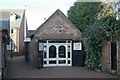
Lewes old fire station, Cliffe High Street
Lewes old fire station, Cliffe High Street, Lewes, East Sussex is now occupied by a silversmiths.
Image: © Kevin Hale
Taken: 9 Nov 2009
0.01 miles
3
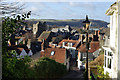
Cliffe from Chapel Hill
The church is known as St. Thomas at Cliffe, actually dedicated to St. Thomas a Becket.
Image: © Robin Webster
Taken: 2 Jan 2007
0.01 miles
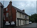
6
The Dorset, Lewes
Harveys of Lewes pub on Malling Street.
Image: © Oast House Archive
Taken: 4 Mar 2011
0.02 miles
10
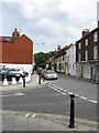
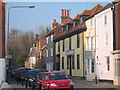
Malling Street
Taken from the junction with Cliffe High Street. Hard to believe that up to the mid 1970s this was the junction of the A27 and A26.
Image: © Simon Carey
Taken: 19 Aug 2012
0.02 miles