IMAGES TAKEN NEAR TO
South Street, LEWES, BN7 2BX
Introduction
This page details the photographs taken nearby to South Street, BN7 2BX by members of the Geograph project.
The Geograph project started in 2005 with the aim of publishing, organising and preserving representative images for every square kilometre of Great Britain, Ireland and the Isle of Man.

There are currently over 7.5m images from over14,400 individuals and you can help contribute to the project by visiting https://www.geograph.org.uk
Image Map
Images are licensed for reuse under creativecommons.org/licenses/by-sa/2.0
Notes
- Clicking on the map will re-center to the selected point.
- The higher the marker number, the further away the image location is from the centre of the postcode.
Image Listing (459 Images Found)
Images are licensed for reuse under creativecommons.org/licenses/by-sa/2.0
Image
Details
Distance
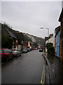
2
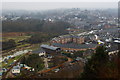
View From Chapel Hill, Lewes, Sussex
Looking over the town, in the direction of Lewes Castle; just visible on the skyline. The River Ouse can be seen, running diagonally across the picture.
Image: © Peter Trimming
Taken: 29 Dec 2010
0.02 miles
3
View from Chapel Hill
Looking north west to where the chimney from Harvey's Brewery is visible, the river Ouse is heading its way out of town, Offham Chalkpit and Offham Hill.
Image: © Simon Carey
Taken: 9 Dec 2006
0.03 miles
4
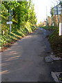
Chapel Hill
The point where Chapel Hill becomes a private drive to Lewes Golf Club.
Image: © Simon Carey
Taken: 9 Dec 2006
0.03 miles
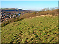
6
Chapel Hill, Lewes, Sussex
Looking up the hill, towards the golf course, from the Cliffe end of Chapel Hill.
Image: © Peter Trimming
Taken: 29 Dec 2010
0.03 miles
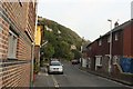
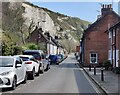
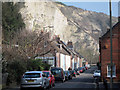
8
South Street
Once the busy A26 choked with heavy lorries from the nearby cement works and from nearby Newhaven on their way north. With the building of the Cuilfail tunnel through part of the old chalk quarries this part of Cliffe has become a sleepy backwater.
Image: © Simon Carey
Taken: 25 Dec 2007
0.03 miles
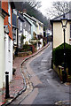
9
South Street
A dead end street towards the centre. This road would once have been the main road into the town but has been bypassed by through the Cuilfail Tunnel behind the buildings to the left. The white cliffs of Cuilfail seen behind.
Image: © Oast House Archive
Taken: 4 Mar 2011
0.04 miles
10
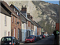
South Street
A dead end street towards the centre. This road would once have been the main road into the town but has been bypassed by through the Cuilfail Tunnel behind the buildings to the left. An emergency gate is provided to avoid the tunnel. The white cliffs of Cuilfail seen behind.
Image: © Oast House Archive
Taken: 4 Mar 2011
0.04 miles