IMAGES TAKEN NEAR TO
Castle Ditch Lane, LEWES, BN7 1YJ
Introduction
This page details the photographs taken nearby to Castle Ditch Lane, BN7 1YJ by members of the Geograph project.
The Geograph project started in 2005 with the aim of publishing, organising and preserving representative images for every square kilometre of Great Britain, Ireland and the Isle of Man.

There are currently over 7.5m images from over14,400 individuals and you can help contribute to the project by visiting https://www.geograph.org.uk
Image Map
Images are licensed for reuse under creativecommons.org/licenses/by-sa/2.0
Notes
- Clicking on the map will re-center to the selected point.
- The higher the marker number, the further away the image location is from the centre of the postcode.
Image Listing (1061 Images Found)
Images are licensed for reuse under creativecommons.org/licenses/by-sa/2.0
Image
Details
Distance
1
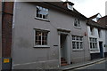
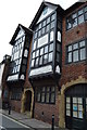
5, Fisher St
Grade II listed. http://www.britishlistedbuildings.co.uk/en-293072-5-fisher-street-lewes-east-sussex
Image: © N Chadwick
Taken: 12 Jul 2015
0.00 miles
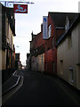
2
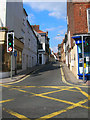
Fisher Street
On the crossroads former by High Street and Station Street it is actually the A277 and is part of an intricate one way system that runs through the narrow streets of central Lewes.
Image: © Simon Carey
Taken: 21 Sep 2008
0.01 miles
3
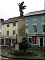
War memorial with shops in Lewes High Street
The war memorial in Lewes sports some fine bronze statues.
Image: © Trevor Littlewood
Taken: 15 Oct 2008
0.01 miles
4
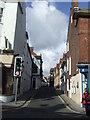
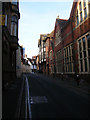
Fisher Street, Lewes
Despite being narrow, Fisher Street in Lewes is classified as an "A" road (A2029, linking the trunk A26 road with the A275).
Image: © Malc McDonald
Taken: 30 Oct 2010
0.01 miles
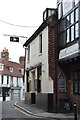
5
The Lamb
Grade II listed. http://www.britishlistedbuildings.co.uk/en-293076-the-lamb-public-house-lewes-east-sussex
Image: © N Chadwick
Taken: 12 Jul 2015
0.01 miles
6
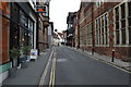
Fisher Street
Looking towards the junction with High Street, it is part of the A277 one way system through the town centre. The western side (right) is home to old warehouses and a former brewery (the yellow building front right).
Image: © Simon Carey
Taken: 4 Feb 2007
0.02 miles
7
Fisher Street
Looking northwards with the town hall to the right.
Image: © Simon Carey
Taken: 4 Feb 2007
0.02 miles
9
The Lamb
Grade II listed. http://www.britishlistedbuildings.co.uk/en-293076-the-lamb-public-house-lewes-east-sussex
Image: © N Chadwick
Taken: 12 Jul 2015
0.02 miles
10
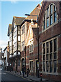
Former Council offices, Fisher Street, Lewes
Former Council premises, Fisher Street, Lewes
Image: © Jim Osley
Taken: 27 Oct 2017
0.02 miles