IMAGES TAKEN NEAR TO
Grange Road, LEWES, BN7 1TU
Introduction
This page details the photographs taken nearby to Grange Road, BN7 1TU by members of the Geograph project.
The Geograph project started in 2005 with the aim of publishing, organising and preserving representative images for every square kilometre of Great Britain, Ireland and the Isle of Man.

There are currently over 7.5m images from over14,400 individuals and you can help contribute to the project by visiting https://www.geograph.org.uk
Image Map
Images are licensed for reuse under creativecommons.org/licenses/by-sa/2.0
Notes
- Clicking on the map will re-center to the selected point.
- The higher the marker number, the further away the image location is from the centre of the postcode.
Image Listing (717 Images Found)
Images are licensed for reuse under creativecommons.org/licenses/by-sa/2.0
Image
Details
Distance
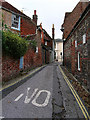
1
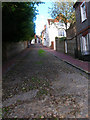
Keere Street
Looking up the cobbled street towards the junction with High Street. The opposite view to this Image which also has all the information you need to know about this street.
Image: © Simon Carey
Taken: 7 Oct 2006
0.03 miles
2
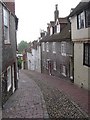
Keere Street, Lewes
From Lewes District Council's website http://www.lewes.gov.uk/leisure/1808.asp "Keere Street, a favourite location for TV and film companies, is also well worth a look. This twitten is a steep cobbled byway linking the town centre to Southover. Flanked by picturesque cottages and with the beamed 15th century bookshop, the street marks the boundary of the medieval town with a fragment of the wall lying behind the houses on the east side. Tradition says that George IV, while Prince of Wales, drove a coach and four down Keere Street for a wager."
And from Lewes Town Council's website http://www.lewes-town.co.uk/infopage.asp?infoid=298 "Keere Street (the street of locksmiths) was partly built on the dry ditch of the town wall. The central watercourse was paved with water-rolled flints (petrified kidneys)."
Image: © Cathy Cox
Taken: 20 Aug 2006
0.04 miles
3
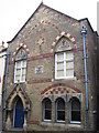
Lewes: Freemasons' Hall
This hall on the High Street was completed in 1868, replacing an earlier building from 1797.
Image: © Nigel Cox
Taken: 20 Aug 2006
0.04 miles
4
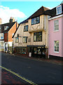
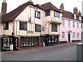
The Fifteenth Century Bookshop, High Street
Built in the 15th century and jutting out at all angles it has been a second-hand bookshop for over 40 years specialising mainly in old children's books. Located on the corner of High Street and Keere Street it has an old milestone on the outside wall giving the mileage to the Standard in Cornhill, Westminster Bridge and Brighthelmstone.
Image: © Simon Carey
Taken: 7 Oct 2006
0.04 miles
7
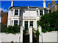
51-53 Grange Road
Victorian houses on the northern side of Grange Road. The rest of the housing on this side of the road was added later.
Image: © Simon Carey
Taken: 7 Oct 2006
0.05 miles
8
Rotten Row, Lewes
Taken from the junction with Antioch Street looking east.
Image: © Simon Carey
Taken: 13 Nov 2005
0.06 miles
9
Antioch Street
In view is the length of the whole street though its medieval course is believed to have continued beyond the ivy clad wall at the far end.
Image: © Simon Carey
Taken: 7 Oct 2006
0.06 miles
10
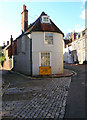
The Old Toll House, High Street
On the junction of High Street and Rotten Row. The toll house would have covered the Lewes to Brighton turnpike now the A27.
Image: © Simon Carey
Taken: 7 Oct 2006
0.06 miles