IMAGES TAKEN NEAR TO
Eastport Lane, LEWES, BN7 1TL
Introduction
This page details the photographs taken nearby to Eastport Lane, BN7 1TL by members of the Geograph project.
The Geograph project started in 2005 with the aim of publishing, organising and preserving representative images for every square kilometre of Great Britain, Ireland and the Isle of Man.

There are currently over 7.5m images from over14,400 individuals and you can help contribute to the project by visiting https://www.geograph.org.uk
Image Map
Images are licensed for reuse under creativecommons.org/licenses/by-sa/2.0
Notes
- Clicking on the map will re-center to the selected point.
- The higher the marker number, the further away the image location is from the centre of the postcode.
Image Listing (847 Images Found)
Images are licensed for reuse under creativecommons.org/licenses/by-sa/2.0
Image
Details
Distance
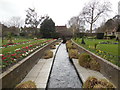
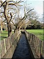
3
Winterbourne Stream, Stream Gardens
As the name suggests a stream that is seen more in winter than summer. The gardens are in the grounds of Southover Grange.
Image: © Simon Carey
Taken: 7 Oct 2006
0.03 miles
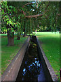
5
Winterbourne Stream
View of the heavily culverted stream as it travels through Southover Grange Gardens. Compare with Image the same view from 2007.
Image: © Simon Carey
Taken: 8 Feb 2009
0.04 miles
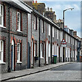
6
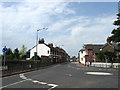
Priory Street
The B2193 viewed from the junction with Mountfield Road and Station Road. The street dates from around the 1830s though the actual highway is of a far greater antiquity being dated back to Roman times being part of a route that forded the Ouse near Southerham then ran along the modern day Mountfield Road, Priory Street, Southover High Street and Juggs Road before continuing westwards to Kingston then Brighton. For many centuries the road itself up to the junction with Southover High Street was known as Ham Lane before this section was renamed in the 1830s and that heading eastwards was renamed Mountfield Road in 1932.
Image: © Simon Carey
Taken: 19 Aug 2012
0.04 miles
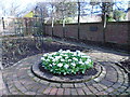
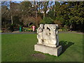
8
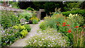
Southover Grange Gardens, 1
Run by the local council, this is a good example of why these facilities continue to be funded for the benefit of locals and tourists like us.
Here is the informal 'cottage' garden.
Image: © Jonathan Billinger
Taken: 8 Jul 2015
0.04 miles