IMAGES TAKEN NEAR TO
East Way, LEWES, BN7 1NG
Introduction
This page details the photographs taken nearby to East Way, BN7 1NG by members of the Geograph project.
The Geograph project started in 2005 with the aim of publishing, organising and preserving representative images for every square kilometre of Great Britain, Ireland and the Isle of Man.

There are currently over 7.5m images from over14,400 individuals and you can help contribute to the project by visiting https://www.geograph.org.uk
Image Map
Images are licensed for reuse under creativecommons.org/licenses/by-sa/2.0
Notes
- Clicking on the map will re-center to the selected point.
- The higher the marker number, the further away the image location is from the centre of the postcode.
Image Listing (27 Images Found)
Images are licensed for reuse under creativecommons.org/licenses/by-sa/2.0
Image
Details
Distance
1
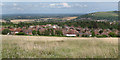
West of Lewes
See more sizes for wider panorama.
Image: © Oast House Archive
Taken: 5 Aug 2012
0.09 miles
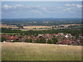
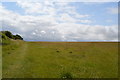
5
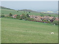
Sheep at Landport Bottom near Lewes
A solitary sheep grazing at Landport Bottom. In the background is the Landport estate, a development of low-density housing on the edge of Lewes.
Image: © Malc McDonald
Taken: 17 Apr 2011
0.17 miles
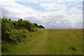
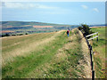
7
Jill's Pond, Landport Bottom, near Lewes
Jill's Pond is a dew pond at Landport Bottom near Lewes.
Image: © Malc McDonald
Taken: 17 Apr 2011
0.18 miles
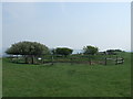
8
Landport Bottom, near Lewes
Landport Bottom near Lewes. This was the site of the Battle of Lewes in the year 1264 A.D.
Image: © Malc McDonald
Taken: 17 Apr 2011
0.20 miles
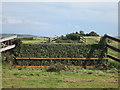
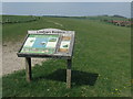
10
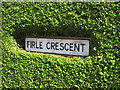
Firle Crescent sign
A neat cut out in the hedge framing the sign.
Image: © Oast House Archive
Taken: 5 Aug 2012
0.21 miles