IMAGES TAKEN NEAR TO
Nevill Crescent, LEWES, BN7 1NB
Introduction
This page details the photographs taken nearby to Nevill Crescent, BN7 1NB by members of the Geograph project.
The Geograph project started in 2005 with the aim of publishing, organising and preserving representative images for every square kilometre of Great Britain, Ireland and the Isle of Man.

There are currently over 7.5m images from over14,400 individuals and you can help contribute to the project by visiting https://www.geograph.org.uk
Image Map
Images are licensed for reuse under creativecommons.org/licenses/by-sa/2.0
Notes
- Clicking on the map will re-center to the selected point.
- The higher the marker number, the further away the image location is from the centre of the postcode.
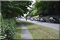
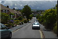
Image Listing (39 Images Found)
Images are licensed for reuse under creativecommons.org/licenses/by-sa/2.0
Image
Details
Distance
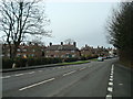
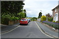
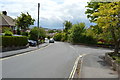
2
Christie Road
Small suburban road linking Wallands Park to Nevill Road, the A275.
Image: © Simon Carey
Taken: 29 Dec 2008
0.08 miles
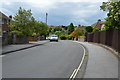
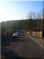
6
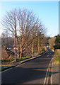
Prince Edward's Road
Named after the son of Henry III who fought alongside his father at the Battle of Lewes in 1264. Much of western Lewes leading up to Offham Hill was the battleground. The road links Offham Road with Nevill Road.
Image: © Simon Carey
Taken: 29 Dec 2008
0.13 miles