IMAGES TAKEN NEAR TO
Phoenix Place, LEWES, BN7 1JX
Introduction
This page details the photographs taken nearby to Phoenix Place, BN7 1JX by members of the Geograph project.
The Geograph project started in 2005 with the aim of publishing, organising and preserving representative images for every square kilometre of Great Britain, Ireland and the Isle of Man.

There are currently over 7.5m images from over14,400 individuals and you can help contribute to the project by visiting https://www.geograph.org.uk
Image Map
Images are licensed for reuse under creativecommons.org/licenses/by-sa/2.0
Notes
- Clicking on the map will re-center to the selected point.
- The higher the marker number, the further away the image location is from the centre of the postcode.
Image Listing (894 Images Found)
Images are licensed for reuse under creativecommons.org/licenses/by-sa/2.0
Image
Details
Distance

3
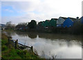
Course of the Lewes to Uckfield Railway
The line between Lewes to Uckfield was shut in 1969 ostensibly due to flooding but in reality due to Lewes Council wanting to build the Phoenix Causeway bypass. The railway travelled through the Cliffe part of Lewes on a viaduct and via embankments, the latter being too expensive to bridge, so some agreement was reached with British Railways to dismantle the line and sell the land, a decision still being felt today by those using the truncated line from Uckfield to London. It was roughly at this point that the railway crossed the river.
Image: © Simon Carey
Taken: 4 Feb 2007
0.04 miles
4
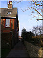
Green Wall
So named as the path once followed the course of the old town wall which would have been on the right hand side. It stretched much further to the north than its current ending at Wellington Street.
Image: © Simon Carey
Taken: 4 Feb 2007
0.05 miles
5
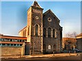
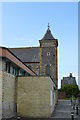
Eastgate Baptist Church, Lewes
When the church was erected in 1843, the tower had been given a ‘pepper box’ ornamentation by an individual who “wanted to put something on top of it”. However, by 1915 the old tower had become unsafe because it was not weather-proof and it was suffering from the vibrations of heavy traffic. So the church removed the ‘pepper box’ and rebuilt the upper part into its present pyramid form. http://lewesbaptistchurch.org.uk/?page_id=383
Image: © Paul Gillett
Taken: 27 Jan 2012
0.05 miles
6
Waterloo Place
Small cul-de-sac off Wellington Street which once would have linked to Little East Street but was shut off when the road was widened to provide access for Phoenix Causeway.
Image: © Simon Carey
Taken: 4 Feb 2007
0.06 miles
7
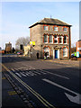
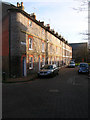
Eastgate House, Eastgate Street
A survivor of the massive rebuilding that has gone on in this street, the house is now a Grade II listed building and awaiting new ownership after the council moved its transport offices to Ringmer. The small building behind Eastgate House is the former Eastgate Stoneworks show rooms whose stone cutters yard was behind it. In the distance the remaining houses of Green Wall can be seen. The area to the right out of picture is now Waitrose Supermarket.
Image: © Simon Carey
Taken: 4 Feb 2007
0.06 miles