IMAGES TAKEN NEAR TO
St. Pancras Road, LEWES, BN7 1JG
Introduction
This page details the photographs taken nearby to St. Pancras Road, BN7 1JG by members of the Geograph project.
The Geograph project started in 2005 with the aim of publishing, organising and preserving representative images for every square kilometre of Great Britain, Ireland and the Isle of Man.

There are currently over 7.5m images from over14,400 individuals and you can help contribute to the project by visiting https://www.geograph.org.uk
Image Map
Images are licensed for reuse under creativecommons.org/licenses/by-sa/2.0
Notes
- Clicking on the map will re-center to the selected point.
- The higher the marker number, the further away the image location is from the centre of the postcode.
Image Listing (379 Images Found)
Images are licensed for reuse under creativecommons.org/licenses/by-sa/2.0
Image
Details
Distance
5
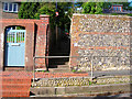
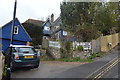
Blink and You'll Miss It!
Church Lane footpath linking Rotten Row with St Anne's Church
Image: © Simon Carey
Taken: 7 Oct 2006
0.04 miles
7
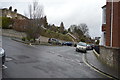
Neglected lawn by County Hall, Lewes
This was in the grounds of the former Southover Rectory, whose land seems to be absorbed into the County Hall plot now. The rectory most recently was a school, now semi-derelict.
Image: © Robin Webster
Taken: 20 Jul 2016
0.05 miles
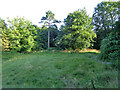
9
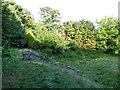
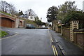
Neglected area with steps by County Hall, Lewes
This was in the grounds of the former Southover Rectory, whose land seems to be absorbed into the County Hall plot now. The rectory most recently was a school, now semi-derelict.
Image: © Robin Webster
Taken: 20 Jul 2016
0.06 miles
10
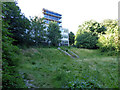
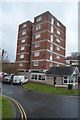
Neglected area with steps by County Hall, Lewes
This was in the grounds of the former Southover Rectory, whose land seems to be absorbed into the County Hall plot now. The rectory most recently was a school, now semi-derelict. There is a half-hearted attempt to cordon this area off, probably the plan is to sell it. Nevertheless there is a well-worn path through it, and I passed a couple of respectable citizens using it.
Image: © Robin Webster
Taken: 20 Jul 2016
0.06 miles