IMAGES TAKEN NEAR TO
St. Pancras Road, LEWES, BN7 1JF
Introduction
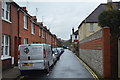
This page details the photographs taken nearby to St. Pancras Road, BN7 1JF by members of the Geograph project.
The Geograph project started in 2005 with the aim of publishing, organising and preserving representative images for every square kilometre of Great Britain, Ireland and the Isle of Man.

There are currently over 7.5m images from over14,400 individuals and you can help contribute to the project by visiting https://www.geograph.org.uk
Image Map
Images are licensed for reuse under creativecommons.org/licenses/by-sa/2.0
Notes
- Clicking on the map will re-center to the selected point.
- The higher the marker number, the further away the image location is from the centre of the postcode.
Image Listing (403 Images Found)
Images are licensed for reuse under creativecommons.org/licenses/by-sa/2.0
Image
Details
Distance
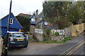
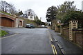
3
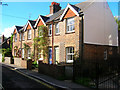
Terraced Cottages, The Course
Next to the entrance of Western Road Primary School.
Image: © Simon Carey
Taken: 7 Oct 2006
0.03 miles
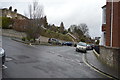
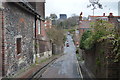
8
Blink and You'll Miss It!
Church Lane footpath linking Rotten Row with St Anne's Church
Image: © Simon Carey
Taken: 7 Oct 2006
0.05 miles
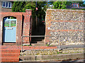
10
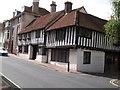
The Three Mariners
Mediaeval cottages at Lewes next to Anne of Cleves Museum
Image: © Raymond Knapman
Taken: 6 Jul 2009
0.07 miles