IMAGES TAKEN NEAR TO
St. Pancras Gardens, LEWES, BN7 1HY
Introduction
This page details the photographs taken nearby to St. Pancras Gardens, BN7 1HY by members of the Geograph project.
The Geograph project started in 2005 with the aim of publishing, organising and preserving representative images for every square kilometre of Great Britain, Ireland and the Isle of Man.

There are currently over 7.5m images from over14,400 individuals and you can help contribute to the project by visiting https://www.geograph.org.uk
Image Map
Images are licensed for reuse under creativecommons.org/licenses/by-sa/2.0
Notes
- Clicking on the map will re-center to the selected point.
- The higher the marker number, the further away the image location is from the centre of the postcode.
Image Listing (280 Images Found)
Images are licensed for reuse under creativecommons.org/licenses/by-sa/2.0
Image
Details
Distance
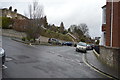
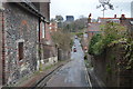
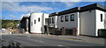
4
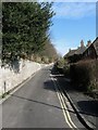
Rotten Row
A back street that starts on High Street then descends the hill towards the Winterbourne Stream.
Image: © Simon Carey
Taken: 8 Feb 2009
0.06 miles
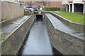
7
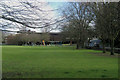
Bell Lane Playing Fields and Playground, Lewes, East Sussex
Photograph taken from Winterbourne Mews.
Image: © Kevin Gordon
Taken: 27 Mar 2008
0.06 miles
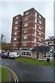
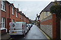
9
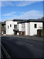
Knilljames, Bell Lane
Chartered accountants who have been operating in Lewes since the 1890s. Both this building and the office block beyond were built in the late 1970s on the site of a former scent factory.
Image: © Simon Carey
Taken: 8 Feb 2009
0.07 miles