IMAGES TAKEN NEAR TO
Priory Street, LEWES, BN7 1HH
Introduction
This page details the photographs taken nearby to Priory Street, BN7 1HH by members of the Geograph project.
The Geograph project started in 2005 with the aim of publishing, organising and preserving representative images for every square kilometre of Great Britain, Ireland and the Isle of Man.

There are currently over 7.5m images from over14,400 individuals and you can help contribute to the project by visiting https://www.geograph.org.uk
Image Map
Images are licensed for reuse under creativecommons.org/licenses/by-sa/2.0
Notes
- Clicking on the map will re-center to the selected point.
- The higher the marker number, the further away the image location is from the centre of the postcode.
Image Listing (767 Images Found)
Images are licensed for reuse under creativecommons.org/licenses/by-sa/2.0
Image
Details
Distance
1
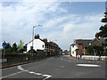
Priory Street
The B2193 viewed from the junction with Mountfield Road and Station Road. The street dates from around the 1830s though the actual highway is of a far greater antiquity being dated back to Roman times being part of a route that forded the Ouse near Southerham then ran along the modern day Mountfield Road, Priory Street, Southover High Street and Juggs Road before continuing westwards to Kingston then Brighton. For many centuries the road itself up to the junction with Southover High Street was known as Ham Lane before this section was renamed in the 1830s and that heading eastwards was renamed Mountfield Road in 1932.
Image: © Simon Carey
Taken: 19 Aug 2012
0.01 miles
3
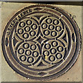
Coal Plate, Priory Street, Lewes
'J.Every Lewes' was a product of the Phoenix Ironworks, a local business that moved around in location in the town, but were probably in North Place when this was made.
Image: © Robin Webster
Taken: 20 Jul 2016
0.02 miles
4
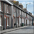
Dorset Road
Small dead end road below Station Road (B2193). The houses on the southern side are older than those on the northern side.
Image: © Simon Carey
Taken: 7 Oct 2006
0.03 miles
5
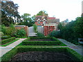
Knot Garden, Stream Gardens
Small garden within Stream Gardens in the grounds of Southover Grange.
Image: © Simon Carey
Taken: 7 Oct 2006
0.03 miles
6
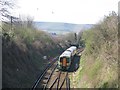
Cutting east of Lewes station
Taken from the Priory Street bridge, with an eastbound train approaching.
Image: © Stephen Craven
Taken: 5 Apr 2007
0.04 miles
7

Lewes Castle
A view south of Lewes from windows in the south tower of the shell keep.
Image: © Michael Garlick
Taken: 12 Mar 2015
0.05 miles
10
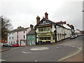
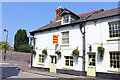
The Kings Head, Lewes
This green-gabled community pub is close to the ruins of the Lewes Priory, the Tudor Grange gardens and Anne of Cleeves House http://www.thekingsheadlewes.co.uk/AboutUs
Image: © Paul Gillett
Taken: 19 Mar 2014
0.06 miles