IMAGES TAKEN NEAR TO
Five Oaks Way, HASSOCKS, BN6 9ZU
Introduction
This page details the photographs taken nearby to Five Oaks Way, BN6 9ZU by members of the Geograph project.
The Geograph project started in 2005 with the aim of publishing, organising and preserving representative images for every square kilometre of Great Britain, Ireland and the Isle of Man.

There are currently over 7.5m images from over14,400 individuals and you can help contribute to the project by visiting https://www.geograph.org.uk
Image Map (Loading...)


Getting Data...Please wait
Leaflet Map data © OpenStreetMap
Images are licensed for reuse under creativecommons.org/licenses/by-sa/2.0
Notes
- Clicking on the map will re-center to the selected point.
- The higher the marker number, the further away the image location is from the centre of the postcode.
Image Listing (16 Images Found)
Images are licensed for reuse under creativecommons.org/licenses/by-sa/2.0
Image
Details
Distance
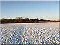
1
Welcome Mead
The name of the field according to the 1838 tithe map. It is crossed by the footpath that links Hassocks with Clayton Wickham.
Image: © Simon Carey
Taken: 20 Dec 2009
0.02 miles
2
Welcome Mead
The name of the field according to the 1838 tithe map. A line of tractors are parked next to the fence separating them from the houses that front onto London Road, the A273.
Image: © Simon Carey
Taken: 20 Dec 2009
0.04 miles
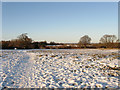
4
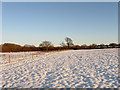
Ham Mead
The name of the field according to the 1838 tithe map and carrying the footpath that links Hassocks to Clayton Wickham.
Image: © Simon Carey
Taken: 20 Dec 2009
0.11 miles
5
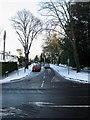
Stanford Avenue
Residential road that leaves London Road, the A273, just north of Stonepound Crossroads and heads towards Hassocks station. Like many residential roads after the snow and ice untreated and hazardous to drive on.
Image: © Simon Carey
Taken: 20 Dec 2009
0.12 miles
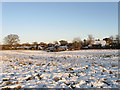
6
Ham Mead
The name of the field according to the 1838 tithe map which stretched beyond the modern fence up to the bushes on the left. Both they and the snow are catching the light of the setting sun.
Image: © Simon Carey
Taken: 20 Dec 2009
0.18 miles
7
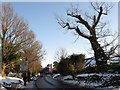
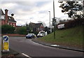
Hurst Road
The name of the B2116 between the parish boundary with Hurstpierpoint and Stonepound Crossroads which can be seen in the distance. There has been a crossroads here since Roman times when two local roads met just to the north of the current one. A woman gingerly makes her way down the pavement towards the centre of Hassocks highlighting a huge problem that occurred in Sussex when the freezing temperatures turned the compacted snow on the pavements into sheet ice which were not gritted at all.
Image: © Simon Carey
Taken: 20 Dec 2009
0.19 miles
9
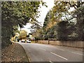
Junction between B2116 and A273 at Hassocks
Image: © nick macneill
Taken: 11 Jan 2011
0.21 miles
10
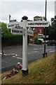
Old Direction Sign - Signpost by the A273, Stonepound Crossroads
Black iron cap finial - 4 arms; East Sussex wood with number by the A273, in parish of Hassocks (District), crossroads where the B2116, Keymer Road and Hurst Road, intersects with the A273, on grass bank above drinking trough.
Surveyed
Milestone Society National ID: SX_TQ2915
Image: © Milestone Society
Taken: Unknown
0.21 miles