IMAGES TAKEN NEAR TO
Brown Twins Road, HASSOCKS, BN6 9XS
Introduction
This page details the photographs taken nearby to Brown Twins Road, BN6 9XS by members of the Geograph project.
The Geograph project started in 2005 with the aim of publishing, organising and preserving representative images for every square kilometre of Great Britain, Ireland and the Isle of Man.

There are currently over 7.5m images from over14,400 individuals and you can help contribute to the project by visiting https://www.geograph.org.uk
Image Map
Images are licensed for reuse under creativecommons.org/licenses/by-sa/2.0
Notes
- Clicking on the map will re-center to the selected point.
- The higher the marker number, the further away the image location is from the centre of the postcode.
Image Listing (62 Images Found)
Images are licensed for reuse under creativecommons.org/licenses/by-sa/2.0
Image
Details
Distance
1
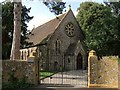
St George's Church, Hurstpierpoint
Built in 1852 after a dispute between the Hannington family who found the local rector, who helped build Holy Trinity Church in 1848, too High church for their liking. Originally called Little Park Chapel it was a private chapel until 1892 when it was presented to the local diocese and remained a chapel at ease until its last service in 2008. It was sold for development in 2012 and is now a private residence.
Image: © Simon Carey
Taken: 13 Jul 2014
0.05 miles
2
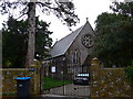
Former St George, Hurstpierpoint
For more information see http://www.achurchnearyou.com/hurstpierpoint-st-george/
Image: © Basher Eyre
Taken: 3 Nov 2014
0.05 miles
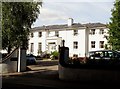
3
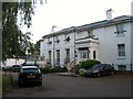
St George's House, Hassocks Road, Hurstpierpoint
A 19th century large house now subdivided into flats.
Image: © Simon Carey
Taken: 7 Aug 2014
0.06 miles
4
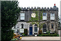
Hurstpierpoint : Gothic House
Grade II listed house : description at this https://historicengland.org.uk/listing/the-list/list-entry/1194813?section=official-list-entry.
Image: © Jim Osley
Taken: 7 Apr 2022
0.07 miles
5
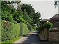
St George's Lane, Hurstpierpoint
Built as an access road for Image in the 1850s. The building on the right is Bee Cottage.
Image: © Simon Carey
Taken: 13 Jul 2014
0.07 miles
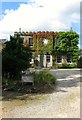
6
St. George's House, Hurstpierpoint
The house has a blue plaque by the door commemorating Bishop John Hannington, a Christian missionary who was martyred in Uganda in 1885. For more information see http://en.wikipedia.org/wiki/James_Hannington.
St. George's House is now a set of apartments.
Image: © nick macneill
Taken: 31 Aug 2012
0.07 miles
7
Gothic House, Hassocks Road, Hurstpierpoint
Built in the early 19th century as a single house which has now been subdivided into two units.
Image: © Simon Carey
Taken: 13 Jul 2014
0.07 miles
8
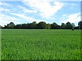
Fifteen Acres
The name of the field according to Hurspierpoint's 1842 tithe map that has been extended to include Image to the east. The village of Hurspierpoint lies beyond the trees in the distance.
Image: © Simon Carey
Taken: 7 Jun 2014
0.08 miles
9
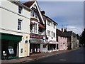
Buildings opposite South Avenue, Hurstpierpoint
Image: © Ian Hawfinch
Taken: 25 Aug 2005
0.08 miles
10
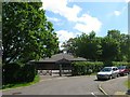
Scout Hall, Brown Twins Road, Hurstpierpoint
Modern building equipped with hall, meeting room and kitchen that replaced the older one now used as Hurstpierpoint Charity Shop.
Image: © Simon Carey
Taken: 31 May 2014
0.09 miles