IMAGES TAKEN NEAR TO
The Chestnuts, HASSOCKS, BN6 9XJ
Introduction
This page details the photographs taken nearby to The Chestnuts, BN6 9XJ by members of the Geograph project.
The Geograph project started in 2005 with the aim of publishing, organising and preserving representative images for every square kilometre of Great Britain, Ireland and the Isle of Man.

There are currently over 7.5m images from over14,400 individuals and you can help contribute to the project by visiting https://www.geograph.org.uk
Image Map
Images are licensed for reuse under creativecommons.org/licenses/by-sa/2.0
Notes
- Clicking on the map will re-center to the selected point.
- The higher the marker number, the further away the image location is from the centre of the postcode.
Image Listing (61 Images Found)
Images are licensed for reuse under creativecommons.org/licenses/by-sa/2.0
Image
Details
Distance
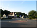
1
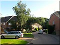
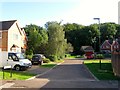
The Chestnuts, Sayers Common
Small cul de sac off Image built in the 1990s in the aftermath of the A23 realignment which bypassed the village. The estate occupies a former field called Home Field which once lay to the south of the former Berrylands Farm which was demolished to make way for it.
Image: © Simon Carey
Taken: 17 Aug 2014
0.01 miles
2
Berrylands Farm
Modern housing estate built on the land between London Road, the B2118, and the A23(T).
Image: © Simon Carey
Taken: 4 Jan 2009
0.02 miles
3
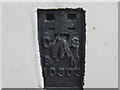
Ordnance Survey Flush Bracket 10303
This Bracket can be found on the wall of the Duke of York PH.
For more details see : http://www.bench-marks.org.uk/bm12997
Image: © Peter Wood
Taken: 3 Apr 2012
0.04 miles
4
Berrylands Farm, Sayers Common
A residential estate built in the 1990s in the aftermath of the A23 realignment which bypassed the village. The estate includes Image, Image, Image and Image which occupies a former field called Home Field which once lay to the south of the former Berrylands Farm which was demolished to make way for it.
Image: © Simon Carey
Taken: 17 Aug 2014
0.04 miles
5
Heath Close, Sayers Common
Small cul de sac off Image built in the 1990s in the aftermath of the A23 realignment which bypassed the village. The estate occupies a former field called Home Field which once lay to the south of the former Berrylands Farm which was demolished to make way for it.
Image: © Simon Carey
Taken: 17 Aug 2014
0.04 miles
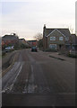
7
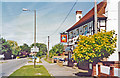
Sayers Common, Duke of York Inn
View northward on the A2118 (Muddleswood - A23) road: it was good for food.
Image: © Ben Brooksbank
Taken: 3 Aug 2003
0.05 miles
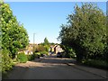
8
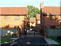
Dukes Place, Sayers Common
A gated estate of 6 houses built in 2013 off London Road.
Image: © Simon Carey
Taken: 17 Aug 2014
0.06 miles
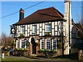
9
Duke of York Inn, London Road, Sayers Common
The inn existed by the publication of Hurstpierpoint's 1842 tithe map and was probably built for the opening of the new London-Brighton turnpike around 1810 which later became the A23. That road was diverted to the east at the beginning of the 1990s bypassing the village and downgrading the old road to the B2118. Viewed from the junction with Reeds Lane.
Image: © Simon Carey
Taken: 31 Jul 2014
0.06 miles
10
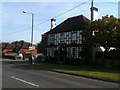
Duke of York public house, Sayers Common
Image: © Stacey Harris
Taken: 25 Sep 2011
0.06 miles