IMAGES TAKEN NEAR TO
Hassocks Road, HASSOCKS, BN6 9QN
Introduction
This page details the photographs taken nearby to Hassocks Road, BN6 9QN by members of the Geograph project.
The Geograph project started in 2005 with the aim of publishing, organising and preserving representative images for every square kilometre of Great Britain, Ireland and the Isle of Man.

There are currently over 7.5m images from over14,400 individuals and you can help contribute to the project by visiting https://www.geograph.org.uk
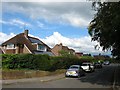
Image Map
Images are licensed for reuse under creativecommons.org/licenses/by-sa/2.0
Notes
- Clicking on the map will re-center to the selected point.
- The higher the marker number, the further away the image location is from the centre of the postcode.
Image Listing (68 Images Found)
Images are licensed for reuse under creativecommons.org/licenses/by-sa/2.0
Image
Details
Distance
1
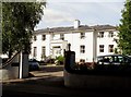
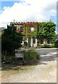
St. George's House, Hurstpierpoint
The house has a blue plaque by the door commemorating Bishop John Hannington, a Christian missionary who was martyred in Uganda in 1885. For more information see http://en.wikipedia.org/wiki/James_Hannington.
St. George's House is now a set of apartments.
Image: © nick macneill
Taken: 31 Aug 2012
0.03 miles
2
Abberton Field, Hurstpierpoint
Small cul de sac off Hassocks Road built in the 1960s in the grounds of Abberton House, whose entrance is on the left.
Image: © Simon Carey
Taken: 7 Aug 2014
0.03 miles
3
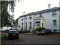
St George's House, Hassocks Road, Hurstpierpoint
A 19th century large house now subdivided into flats.
Image: © Simon Carey
Taken: 7 Aug 2014
0.03 miles
4
Hurstpierpoint : Gothic House
Grade II listed house : description at this https://historicengland.org.uk/listing/the-list/list-entry/1194813?section=official-list-entry.
Image: © Jim Osley
Taken: 7 Apr 2022
0.03 miles
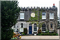
5
Gothic House, Hassocks Road, Hurstpierpoint
Built in the early 19th century as a single house which has now been subdivided into two units.
Image: © Simon Carey
Taken: 13 Jul 2014
0.04 miles
6
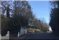
Hassocks Road
The Hassocks Road looking towards the junction with St Georges Lane.
Image: © Chris Thomas-Atkin
Taken: 15 Mar 2018
0.05 miles
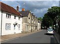
7
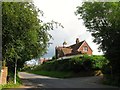
Wych House, Hassocks Road, Hurstpierpoint
Built in the last quarter of the 19th century and viewed from the junction of Hassocks Road and St George's Lane.
Image: © Simon Carey
Taken: 13 Jul 2014
0.06 miles
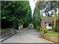
8
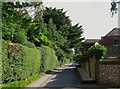
St George's Lane, Hurstpierpoint
Built as an access road for Image in the 1850s. The building on the right is Bee Cottage.
Image: © Simon Carey
Taken: 13 Jul 2014
0.07 miles
9
St George's Place, Hurstpierpoint
Small cul de sac off Image and laid out at the end of the 1950s.
Image: © Simon Carey
Taken: 13 Jul 2014
0.08 miles
10
157-175, High Street,Hurstpierpoint
The white building on the left is 157 and was built in the 18th century. Numbers 159-175 are the terrace to its east and was constructed in 1830, a couple of which seem to have been shops sometime in the past.
Image: © Simon Carey
Taken: 13 Jul 2014
0.08 miles