IMAGES TAKEN NEAR TO
London Road, HASSOCKS, BN6 9NB
Introduction
This page details the photographs taken nearby to London Road, BN6 9NB by members of the Geograph project.
The Geograph project started in 2005 with the aim of publishing, organising and preserving representative images for every square kilometre of Great Britain, Ireland and the Isle of Man.

There are currently over 7.5m images from over14,400 individuals and you can help contribute to the project by visiting https://www.geograph.org.uk
Image Map
Images are licensed for reuse under creativecommons.org/licenses/by-sa/2.0
Notes
- Clicking on the map will re-center to the selected point.
- The higher the marker number, the further away the image location is from the centre of the postcode.
Image Listing (19 Images Found)
Images are licensed for reuse under creativecommons.org/licenses/by-sa/2.0
Image
Details
Distance
1
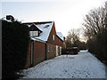
Hammonds Mill Cottages
Next to the bridleway that links Hammonds Mill Farm with Clayton Wickham Farm.
Image: © Simon Carey
Taken: 20 Dec 2009
0.01 miles
2
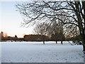
Mill Meadow
The name of the field according to the 1838 tithe map and viewed from a gate next to Hammonds Mill Cottages.
Image: © Simon Carey
Taken: 20 Dec 2009
0.04 miles
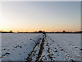
3
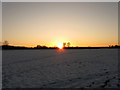
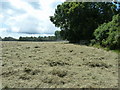
Upper Trees Field
The name of this section of the field according to the 1838 tithe map that has been extended westwards to include Furze Field. The sun is just about to sink beneath the hedgerow on the southern side of the field.
Image: © Simon Carey
Taken: 20 Dec 2009
0.09 miles
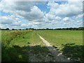
4
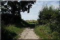
Footpath to Hurstpierpoint College
Seen from the path to Burgess Hill.
Image: © Peter Trimming
Taken: 24 Aug 2019
0.10 miles
5
Bridleway and Ditch near Hammonds Mill Cottages
The bridleway is on the right and heads west to Hurstpierpoint College whilst the ditch separates two fields Upper Trees Field on the left and Little Trees Field to the right.
Image: © Simon Carey
Taken: 20 Dec 2009
0.12 miles
6
Bridleway 4/2C to Hurstpierpoint College
Image: © Dave Spicer
Taken: 24 Jul 2011
0.13 miles
7
Old Mead
The name of this section of the field according to the 1838 tithe map that has been extended to include Single Barn Mead to the south and Six Acres and Walks Field to the north. The field is catching the last sun of the day.
Image: © Simon Carey
Taken: 20 Dec 2009
0.14 miles
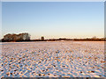
8
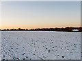
Furze Field
The name of this section of the field according to the 1838 tithe map that has been extended eastwards to include Upper Trees Field. The snow covered roof of Hammonds Mill Cottages can be seen in the distance to the left.
Image: © Simon Carey
Taken: 20 Dec 2009
0.15 miles
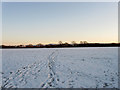
10
Little Tree Field
The name of this section of the field according to the 1838 tithe map that has been extended to include Mill Field to the north and Bushy and Denchy Field to the west.
Image: © Simon Carey
Taken: 20 Dec 2009
0.18 miles