IMAGES TAKEN NEAR TO
Pookbourne Lane, HASSOCKS, BN6 9HD
Introduction
This page details the photographs taken nearby to Pookbourne Lane, BN6 9HD by members of the Geograph project.
The Geograph project started in 2005 with the aim of publishing, organising and preserving representative images for every square kilometre of Great Britain, Ireland and the Isle of Man.

There are currently over 7.5m images from over14,400 individuals and you can help contribute to the project by visiting https://www.geograph.org.uk
Image Map
Images are licensed for reuse under creativecommons.org/licenses/by-sa/2.0
Notes
- Clicking on the map will re-center to the selected point.
- The higher the marker number, the further away the image location is from the centre of the postcode.
Image Listing (30 Images Found)
Images are licensed for reuse under creativecommons.org/licenses/by-sa/2.0
Image
Details
Distance
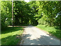
1
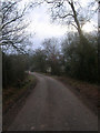
Pookbourne Lane
Minor road linking the A2300 with Cobb's Mill. This view takes in the bridge over Pook Bourne.
Image: © Simon Carey
Taken: 4 Jan 2009
0.04 miles
2
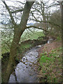
Pook Bourne
A tributary of Herrings Stream that rises in western Burgess Hill and makes its confluence on the eastern side of the A23 at Hickstead. Taken from the bridge on Pookbourne Lane.
Image: © Simon Carey
Taken: 4 Jan 2009
0.06 miles
3
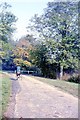
Pookbourne Lane
At the point where it crosses the Pook Bourne Stream.
Image: © Peter Jeffery
Taken: Unknown
0.07 miles
4
Pookbourn
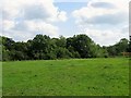
The name of the field according to Hurstpierpoint's 1842 tithe map that lies to the north of Image and west of Image Pookbourne Lane provides the western boundary whilst a little to the north is Pook Bourne a tributary of Herrings Stream.
Image: © Simon Carey
Taken: 22 Jul 2014
0.09 miles
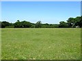
5
Site of Pookbourne Farm
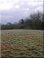
The small triangular field wedged between a stream, Pook Bourne, to the left, and Pookbourne Lane to the right was once the site of Pookbourne Farm. Marked as Pookbarn on the 1813 OS map, Pook Bourne on the 1842 Hurstpierpoint tithe map, it was given the suffix farm on the 1876 OS map before being reduced once more to Pookbourne Barn on the 1910 version. The remains of the barn can still be seen in the distance. The field has been joined to Image to the north.
Image: © Simon Carey
Taken: 22 Jul 2014
0.13 miles
6
Old Barn, Pooksbourne Lane
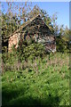
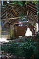
Taken from the footpath that links the lane with Goddard's Green. The barn looks better from this side, closer inspection reveals one of the front supports has collapsed, there are gaps in brickwork on the eastern side and the roof is very dilapidated.
Image: © Simon Carey
Taken: 4 Jan 2009
0.13 miles
10
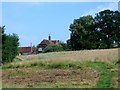
Hornsdene Farm
The farm was known as Ebbetts on Hurstpierpoint's 1842 tithe map, Horns on the 1876 OS map and its current name by the 1937 version.
Image: © Simon Carey
Taken: 25 Jul 2014
0.13 miles