IMAGES TAKEN NEAR TO
Albourne Road, HASSOCKS, BN6 9ET
Introduction
This page details the photographs taken nearby to Albourne Road, BN6 9ET by members of the Geograph project.
The Geograph project started in 2005 with the aim of publishing, organising and preserving representative images for every square kilometre of Great Britain, Ireland and the Isle of Man.

There are currently over 7.5m images from over14,400 individuals and you can help contribute to the project by visiting https://www.geograph.org.uk
Image Map
Images are licensed for reuse under creativecommons.org/licenses/by-sa/2.0
Notes
- Clicking on the map will re-center to the selected point.
- The higher the marker number, the further away the image location is from the centre of the postcode.
Image Listing (56 Images Found)
Images are licensed for reuse under creativecommons.org/licenses/by-sa/2.0
Image
Details
Distance
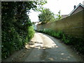
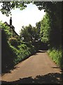
1
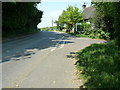
Cottage at the corner of Langton Lane and Albourne Road
On the western edge of Hurstpierpoint at West Town Hurstpierpoint.
Image: © Dave Spicer
Taken: 30 Apr 2011
0.04 miles
2
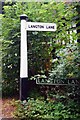
Old Direction Sign - Signpost by the B2116, west of Hurstpierpoint
Black iron cap finial - 1 arm; East Sussex wood by the B2116, in parish of Hurstpierpoint (Mid Sussex District), junction of Langton Lane with Albourne Road, grass verge.
Surveyed
Milestone Society National ID: SX_TQ2716.
Image: © Milestone Society
Taken: Unknown
0.06 miles
3
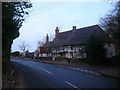
Pigwidgeon Cottage, Albourne Road
On the corner of the B2116 and Langston Lane. Previously known as Crouch Cottages the eastern side of the building dates from 1490 whilst the western portion is a 17th century extension. The building is currently two dwellings with Pigwidgeon Cottage being the eastern portion.
Image: © Simon Carey
Taken: 4 Jan 2009
0.06 miles
4
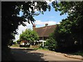
Spotted Cow Cottage/Pigwidgeon Cottage, Albourne Road, West Town
Pigwidgeon Cottage is on the right and was originally a 15th century Wealden hall house. Spotted Cow Cottage to the left is a 17th century addition that was given a tile hung extension in the 18th. The building is located on the junction of Albourne Road and Langton Lane.
Image: © Simon Carey
Taken: 31 May 2014
0.06 miles
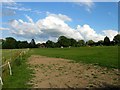
5
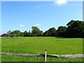
Upper New Ground
The name of the field according to Hurspierpoint's 1842 tithe map that is now a series of paddocks. In the distance to the left is Pakyns House built in the former grounds of Pakyn Manor. The current field is bounded by Image to the west and Image to the south.
Image: © Simon Carey
Taken: 31 May 2014
0.07 miles
7
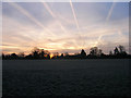
Sunrise over West Town
Taken from a field outside West Town Farm, the trails of planes from nearby Gatwick Airport making interesting patterns in the sky.
Image: © Simon Carey
Taken: 4 Jan 2009
0.09 miles
8
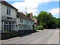
Cottages, Albourne Road, West Town
From left to right, Ham Croft, West Town House and Pakyns Lodge. The first two date from the mid 19th century whilst the lodge was built in the last quarter of that century and lies at the junction with Bullfinch Lane.
Image: © Simon Carey
Taken: 31 May 2014
0.10 miles
9
North Field
The name of the field according to Hurstpierpoint's 1842 tithe map that lies to the south of Image, north of the B2116, west of Langton Lane and south east of Image The house in the south east corner on the right of the image is Image
Image: © Simon Carey
Taken: 13 Jul 2014
0.11 miles
10
Box House Farm, Langton Lane, West Town
The farmhouse dates from at least the 17th century.
Image: © Simon Carey
Taken: 31 May 2014
0.12 miles