IMAGES TAKEN NEAR TO
Truslers Hill Lane, HASSOCKS, BN6 9DU
Introduction
This page details the photographs taken nearby to Truslers Hill Lane, BN6 9DU by members of the Geograph project.
The Geograph project started in 2005 with the aim of publishing, organising and preserving representative images for every square kilometre of Great Britain, Ireland and the Isle of Man.

There are currently over 7.5m images from over14,400 individuals and you can help contribute to the project by visiting https://www.geograph.org.uk
Image Map (Loading...)


Getting Data...Please wait
Leaflet Map data © OpenStreetMap
Images are licensed for reuse under creativecommons.org/licenses/by-sa/2.0
Notes
- Clicking on the map will re-center to the selected point.
- The higher the marker number, the further away the image location is from the centre of the postcode.
Image Listing (37 Images Found)
Images are licensed for reuse under creativecommons.org/licenses/by-sa/2.0
Image
Details
Distance
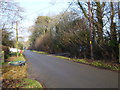
1
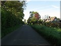
Truslers Hill Lane
Looking northward along the lane that links Poyning Crossways to High Cross. The road can be become a bit of a rat run when the A23 suffers an accident or closure. However, on this morning much of the traffic were cyclists.
Image: © Simon Carey
Taken: 3 May 2014
0.04 miles
2

Black Bush (1)
The name of the field according to Albourne's 1839 tithe map that lies adjacent to Image beyond the hedge to the left and has been extended to include Image out of shot to the right. Beyond the former is another field that shares the same name, see Image The line of trees at the bottom of the field marks the drive to Albourne Place.
Image: © Simon Carey
Taken: 16 May 2014
0.05 miles
3

Black Bush (3)
The name of the field according to Woodmancote's 1839 tithe map. See also Image that lies to the south in what is the same field though this rectangular chunk at the northern end lies within the neighbouring parish of Woodmancote. At some point in the far past when the field was divided into strips ownership was probably divided between two neighbouring manors hence the irregularity of the parish boundary between the two around Wick Farm.
Image: © Simon Carey
Taken: 16 May 2014
0.05 miles
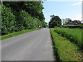
4

Truslers Hill Lane
Minor road running north to High Cross. As it passes Image it becomes Image as it heads south to Poynings Crossways.
Image: © Simon Carey
Taken: 16 May 2014
0.08 miles
5
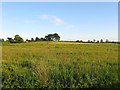
Field Number 259
The number of the field according to Albourne's 1839 tithe map that lacks a name but is bounded by Truslers Hill Lane to the east, Image to the west, Image to the north and Image to the south. Hogs Bottom is the house on the left whilst the dark area of ground on the far right is Image
Image: © Simon Carey
Taken: 25 May 2014
0.08 miles
6
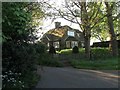
Albourne Place Lodge, Truslers Hill Lane
Dating from the interwar period when Albourne Place decided to make Truslers Hill lane its main access road. Prior to that the drive to the house seems to have started from the end of Church Lane.
Image: © Simon Carey
Taken: 3 May 2014
0.08 miles
7
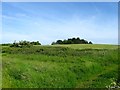
Site of Blackbush Barn
Still marked on OS maps up to the 1980s but all that remains of the former barn is a large area of nettles. The field beyond is Image
Image: © Simon Carey
Taken: 25 May 2014
0.10 miles
8
5-6, Wick Farm, Truslers Hill Lane
The name of the cottages on the right that were built during the interwar period for workers on nearby Wick Farm.
Image: © Simon Carey
Taken: 3 May 2014
0.11 miles