IMAGES TAKEN NEAR TO
Clayton Avenue, HASSOCKS, BN6 8HD
Introduction
This page details the photographs taken nearby to Clayton Avenue, BN6 8HD by members of the Geograph project.
The Geograph project started in 2005 with the aim of publishing, organising and preserving representative images for every square kilometre of Great Britain, Ireland and the Isle of Man.

There are currently over 7.5m images from over14,400 individuals and you can help contribute to the project by visiting https://www.geograph.org.uk
Image Map
Images are licensed for reuse under creativecommons.org/licenses/by-sa/2.0
Notes
- Clicking on the map will re-center to the selected point.
- The higher the marker number, the further away the image location is from the centre of the postcode.
Image Listing (71 Images Found)
Images are licensed for reuse under creativecommons.org/licenses/by-sa/2.0
Image
Details
Distance
1
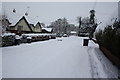
Clayton Avenue, Hassocks snowscene
Clayton Avenue, Hassocks in snow February 2009
Image: © David Cumberland
Taken: 2 Feb 2009
0.02 miles
2
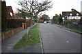
Clayton Avenue, Hassocks
Looking east down Clayton Avenue in Hassocks
Image: © David Cumberland
Taken: 29 Dec 2008
0.04 miles
3

Footpath to the South Downs
Hassocks station became important in Edwardian times as a convenient railhead for the South Downs - a role that continues today. It is approximately two miles from here to the top of the escarpment, a walk that can be done almost entirely without walking along roads by using this footpath that runs parallel to the railway. The Hassocks Parish Council sign makes this clear, but first it is necessary to negotiate the steps.
Image: © Stephen McKay
Taken: 7 Sep 2021
0.08 miles
4
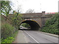
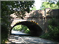
Keymer Road, Hassocks
Keymer Road passing under a railway bridge at Hassocks. The bridge carries the London to Brighton main line over the road.
Image: © Malc McDonald
Taken: 13 Apr 2019
0.09 miles
5
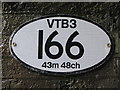
Plaque on the Railway bridge over Keymer Road (B2116)
See Image
Image: © Mike Quinn
Taken: 3 Sep 2009
0.09 miles
8
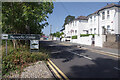
Station Approach, Hassocks
Station Approach leads up from the centre of the village to the railway station, a fact made clear by the modern Southern Railway sign. The Hassocks name has nothing to do with having warm feet, but derives from an Old English word meaning 'clump of coarse grass'. The village is entirely a 19th century creation that developed after the railway station opened.
Image: © Stephen McKay
Taken: 7 Sep 2021
0.10 miles
9
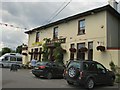
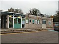
The Hassocks Pub
East of Hassocks station
Image: © Paul Gillett
Taken: 24 Jul 2010
0.10 miles
10
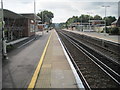
Hassocks railway station, West Sussex
Opened in 1841 as "Hassocks Park" by the London & Brighton Railway, it received its current name in 1881.
View south towards Preston Park and Brighton, showing the 2013-rebuilt station buildings. For a similar view before the rebuild, see Image
Image: © Nigel Thompson
Taken: 18 Sep 2016
0.11 miles