IMAGES TAKEN NEAR TO
Woodsland Road, HASSOCKS, BN6 8ET
Introduction
This page details the photographs taken nearby to Woodsland Road, BN6 8ET by members of the Geograph project.
The Geograph project started in 2005 with the aim of publishing, organising and preserving representative images for every square kilometre of Great Britain, Ireland and the Isle of Man.

There are currently over 7.5m images from over14,400 individuals and you can help contribute to the project by visiting https://www.geograph.org.uk
Image Map
Images are licensed for reuse under creativecommons.org/licenses/by-sa/2.0
Notes
- Clicking on the map will re-center to the selected point.
- The higher the marker number, the further away the image location is from the centre of the postcode.
Image Listing (68 Images Found)
Images are licensed for reuse under creativecommons.org/licenses/by-sa/2.0
Image
Details
Distance
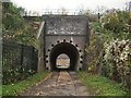
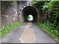
6
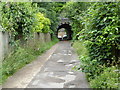
Access road under railway
See also http://www.geograph.org.uk/photo/2158682 from 2010.
Image: © Shazz
Taken: 22 Jun 2016
0.09 miles
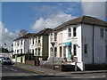
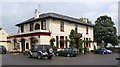
9
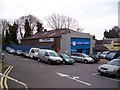
Station Garage, Hassocks
View from the station towards the garage.
Image: © David P Howard
Taken: 7 Apr 2010
0.10 miles
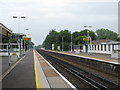
10
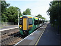
Hassocks Station - train arriving from London
Image: © Ian Hawfinch
Taken: 11 Jun 2006
0.10 miles