IMAGES TAKEN NEAR TO
Shepherds Walk, HASSOCKS, BN6 8ED
Introduction
This page details the photographs taken nearby to Shepherds Walk, BN6 8ED by members of the Geograph project.
The Geograph project started in 2005 with the aim of publishing, organising and preserving representative images for every square kilometre of Great Britain, Ireland and the Isle of Man.

There are currently over 7.5m images from over14,400 individuals and you can help contribute to the project by visiting https://www.geograph.org.uk
Image Map
Images are licensed for reuse under creativecommons.org/licenses/by-sa/2.0
Notes
- Clicking on the map will re-center to the selected point.
- The higher the marker number, the further away the image location is from the centre of the postcode.
Image Listing (26 Images Found)
Images are licensed for reuse under creativecommons.org/licenses/by-sa/2.0
Image
Details
Distance
2
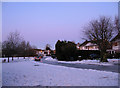
Shepherds Walk
A car tries to negotiate the residential road that is covered in sheet ice.
Image: © Simon Carey
Taken: 20 Dec 2009
0.07 miles
3
Entrance to the Shepherds Walk Estate
Looking along the Southern part of the estate from London Road with the London Brighton railway line on the embankment in the distance.
Image: © Geoff Dent
Taken: 4 May 2008
0.08 miles
4
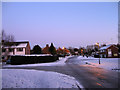
Shepherds Walk
Small estate on the north western side of Hassocks. Shepherds Walk also branches off to the left in the foreground whilst Priory Road heads right beyond. All roads are covered in sheet ice making walking difficult on them let alone driving.
Image: © Simon Carey
Taken: 20 Dec 2009
0.09 miles
5
London bound
Having emerged from the Clayton Tunnel two kilometres south, the next station is Burgess Hill two kilometres north.
Image: © Dave Spicer
Taken: 24 Jul 2011
0.12 miles
6
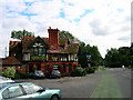
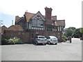
Friars Oak Inn, Hassocks
The Inn was built circa 1900 replacing an older one of the same name that had been erected sometime in the late 18th/early 19th century to serve a London-Brighton turnpike that passed along the course of the current A273. It also has a literary connection appearing in Conan Doyle's story 'Rodney Stone'.
[Many thanks to William Lovell for providing corrected and extra information]
Image: © Simon Carey
Taken: 24 Sep 2005
0.13 miles
7
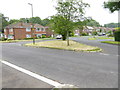
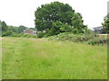
Grass triangle at junction of Priory and Friars Oak Roads
Image: © Shazz
Taken: 22 Jun 2016
0.14 miles
9
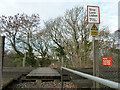
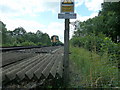
Woodside footpath crossing, Brighton Main Line, 2010
Footpath Hassocks 5K crosses, now replaced by a subway.
Image: © Robin Webster
Taken: 14 Dec 2010
0.15 miles
10
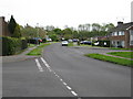
Friars Oak Public House, Hassocks
On the London Road
website: http://www.vintageinn.co.uk/thefriarsoakhassocks/
Image: © Paul Gillett
Taken: 31 Jul 2014
0.15 miles