IMAGES TAKEN NEAR TO
Chanctonbury View, HENFIELD, BN5 9TW
Introduction
This page details the photographs taken nearby to Chanctonbury View, BN5 9TW by members of the Geograph project.
The Geograph project started in 2005 with the aim of publishing, organising and preserving representative images for every square kilometre of Great Britain, Ireland and the Isle of Man.

There are currently over 7.5m images from over14,400 individuals and you can help contribute to the project by visiting https://www.geograph.org.uk
Image Map
Images are licensed for reuse under creativecommons.org/licenses/by-sa/2.0
Notes
- Clicking on the map will re-center to the selected point.
- The higher the marker number, the further away the image location is from the centre of the postcode.
Image Listing (187 Images Found)
Images are licensed for reuse under creativecommons.org/licenses/by-sa/2.0
Image
Details
Distance
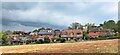
2
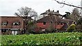
Chanctonbury View, Henfield
A cul de sac off Dropping Holms that was built in the early 1990s on the site of a former field called The Moors according to henfield's 1844 tithe map.
Image: © Simon Carey
Taken: 14 May 2017
0.02 miles
3
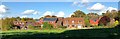
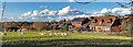
Rear view of houses on Chanctonbury View
The triangular field in the foreground was threatened with development. The threat now seems to have subsided, though who knows what may happen in the future if planning laws or regulations change? The parish council (I think) have placed a seat at the top of the field with an inscription extolling the virtues of the view to be had from that point - as if to put down a marker and say "hands off!".
Image: © Ian Hawfinch
Taken: 22 Oct 2020
0.02 miles
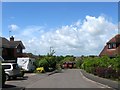
5
Henfield, Sussex - view northwards from Sandy Lane
There were plans to build houses on the field in the foreground, but I think they have been shelved.
Image: © Ian Hawfinch
Taken: 4 Feb 2020
0.03 miles
6
View towards Chanctonbury View from Sandy Lane
There were plans to build houses on the triangular field in the foreground, but I think they've been dropped.
Image: © Ian Hawfinch
Taken: 2 Mar 2020
0.05 miles
7
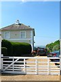
Henfield House, Croft Lane, Henfield
Located at the northern end of Croft Lane. Built in the 1860s and originally known as Broomfield Villa and later Broomfield House. The South Downs can be seen in the distance and probably gives some idea of the excellent views from the southern side of the house.
Image: © Simon Carey
Taken: 9 Jul 2017
0.06 miles
8
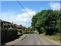
Dropping Holms, Henfield
The name of this section of road between Image to the east and Image to the west. The road name itself was first mentioned in records in 1633 when it was a rural highway heading westwards to Bineham Bridge.
Image: © Simon Carey
Taken: 14 May 2017
0.06 miles
9
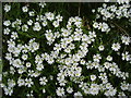
Greater Stitchwort - Stellaria holostea
Image: © Ian Hawfinch
Taken: 24 Apr 2009
0.06 miles
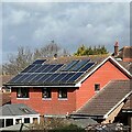
10
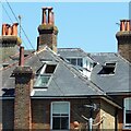
Hot day in Henfield
The open skylights tell a story. This house is on Broomfield Road.
Image: © Ian Hawfinch
Taken: 18 Jul 2021
0.07 miles