IMAGES TAKEN NEAR TO
Blackstone Lane, HENFIELD, BN5 9TA
Introduction
This page details the photographs taken nearby to Blackstone Lane, BN5 9TA by members of the Geograph project.
The Geograph project started in 2005 with the aim of publishing, organising and preserving representative images for every square kilometre of Great Britain, Ireland and the Isle of Man.

There are currently over 7.5m images from over14,400 individuals and you can help contribute to the project by visiting https://www.geograph.org.uk
Image Map
Images are licensed for reuse under creativecommons.org/licenses/by-sa/2.0
Notes
- Clicking on the map will re-center to the selected point.
- The higher the marker number, the further away the image location is from the centre of the postcode.
Image Listing (17 Images Found)
Images are licensed for reuse under creativecommons.org/licenses/by-sa/2.0
Image
Details
Distance
1
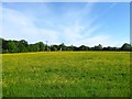
Lime Field/Barbers Field
The name of the fields according to Woodmancote's 1839 tithe map that have been joined together to make a larger unit. Lime Field was in the foreground whilst Barbers Field was in the distance adjacent to the house in view called Barbers Cottage. The trees on the left mark the course of Blackstone Lane.
Image: © Simon Carey
Taken: 25 May 2014
0.08 miles
2
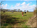
Teatime near Woodmancote
Taken from the footpath that links Blackstone Lane with Woodmancote Place. This field is near the junction of the former and looks north north east.
Image: © Simon Carey
Taken: 1 Apr 2006
0.09 miles
3
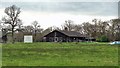
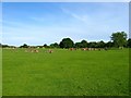
Cricket pavilion at Allfield Ground
I took this telephoto shot from the public footpath to the north of the ground.
Image: © Ian Hawfinch
Taken: 3 Mar 2020
0.10 miles
4
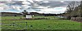
Allfield (cricket) Ground on Blackstone Lane
Image: © Ian Hawfinch
Taken: 3 Mar 2020
0.10 miles
5
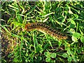
Oak Eggar Moth Caterpillar
Hiding in the grass on the public footpath that links Blackstone Lane to Woodmancote church.
Image: © Simon Carey
Taken: 25 May 2014
0.10 miles
6
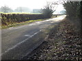
Blackstone Lane
The building is the pavilion at Allfield Ground.
Image: © Shazz
Taken: 17 Jan 2017
0.10 miles
7
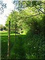
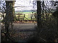
Footpath next to Blackstone Lane
Squeezed between the lane beyond the trees to the right and the deer fence belonging to Woodmancote Place Deer Park to the left. The path links two east-west paths and is getting quite overgrown probably through lack of use as it is just as easy walking down the lane to link the two.
Image: © Simon Carey
Taken: 25 May 2014
0.14 miles
8
East Frogs/Middle Frogs/Eleven Acres
The name of the fields according to Woodmancote's 1839 tithe map that have been joined together to make a larger unit. East Frogs was in the foreground to the left, Middle Frogs was in the foreground to the left whilst Eleven Acres occupied the southern end and included the area that is now a cricket ground in the distance.
Image: © Simon Carey
Taken: 25 May 2014
0.18 miles
10
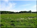
Site of Woodmancote Wood
The wood appeared on the 1876 OS map but had been grubbed by the 1899 edition with the exception of a couple of strips to the north and west, see Image Since 2002 the field has been part of Woodmancote Place Deer Park whose inhabitants can be seen in the distance.
Image: © Simon Carey
Taken: 25 May 2014
0.20 miles