IMAGES TAKEN NEAR TO
New Barn Lane, HENFIELD, BN5 9SJ
Introduction
This page details the photographs taken nearby to New Barn Lane, BN5 9SJ by members of the Geograph project.
The Geograph project started in 2005 with the aim of publishing, organising and preserving representative images for every square kilometre of Great Britain, Ireland and the Isle of Man.

There are currently over 7.5m images from over14,400 individuals and you can help contribute to the project by visiting https://www.geograph.org.uk
Image Map
Images are licensed for reuse under creativecommons.org/licenses/by-sa/2.0
Notes
- Clicking on the map will re-center to the selected point.
- The higher the marker number, the further away the image location is from the centre of the postcode.
Image Listing (37 Images Found)
Images are licensed for reuse under creativecommons.org/licenses/by-sa/2.0
Image
Details
Distance
1
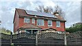
House near the bend in Newbarn Lane
I took this photograph from the public footpath that runs roughly north-south past the right-angle bend in Newbarn Lane. Newbarn Lane is a private road, and I can say from personal experience that at least one of its residents objects to walkers using it to cut through to the A2037. They don't live in this house, I hasten to add!
Image: © Ian Hawfinch
Taken: 9 Nov 2020
0.03 miles
2
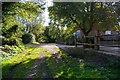
New Barn Cottage
This is the Bridle path from Henfield Common to West Mill at New Barn Cottage
Image: © Glyn Baker
Taken: 7 Oct 2006
0.04 miles
3
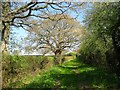
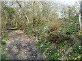
Green Lane near New Barn
Taking a section of footpath from Lepride Farm to Broadmere Common. The farm now accesses the world via Newbarn Lane and the lane is little more than a public footpath.
Image: © Simon Carey
Taken: 9 Apr 2017
0.06 miles
4
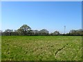
Earth Plot
The name of the field according to Henfield's 1844 tithe map that is bounded by Image to the north and Image to the west.
Image: © Simon Carey
Taken: 9 Apr 2017
0.07 miles
5
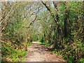
Footpath north of New Barn Farm
A pleasant although seasonally muddy sunken lane. The bright green along the path is a species of Allium, growing densely like Ramsons, but with long and fairly slender leaves.
Image: © Robin Webster
Taken: 25 Mar 2011
0.10 miles
6
Further Gores
The name of the field according to Henfield's 1844 tithe map that is bounded by Image to the east and Image to the west. Gores were small parcels of land often trinagular in shape left behind when medieval farmers had staked out their individual rectangular furlongs.
Image: © Simon Carey
Taken: 9 Apr 2017
0.11 miles
7
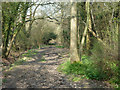
Footpath to Broadmere Common
The original northern part of Newbarn Lane connecting the farms to the south with the common. The lane was later rerouted eastwards to join Shoreham Road. There is a distinct holloway as the track descends towards the common.
Image: © Simon Carey
Taken: 9 Apr 2017
0.11 miles
8
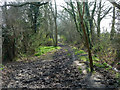
Path south from Broadmare Common
A muddy route.
Image: © Robin Webster
Taken: 25 Mar 2011
0.13 miles
9
Path towards Broadmare Common
A muddy route.
Image: © Robin Webster
Taken: 25 Mar 2011
0.14 miles
10
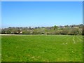
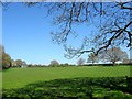
Gores Mead
The name of the field according to Henfield's 1844 tithe map that is bounded by Broadmere Common to the north, Image to the east and Image to the south. Beyond the land rises towards the ridge that contains the village of Henfield with Image visible in the distance to the left.
Image: © Simon Carey
Taken: 9 Apr 2017
0.14 miles