IMAGES TAKEN NEAR TO
Mill Drive, HENFIELD, BN5 9RY
Introduction
This page details the photographs taken nearby to Mill Drive, BN5 9RY by members of the Geograph project.
The Geograph project started in 2005 with the aim of publishing, organising and preserving representative images for every square kilometre of Great Britain, Ireland and the Isle of Man.

There are currently over 7.5m images from over14,400 individuals and you can help contribute to the project by visiting https://www.geograph.org.uk
Image Map
Images are licensed for reuse under creativecommons.org/licenses/by-sa/2.0
Notes
- Clicking on the map will re-center to the selected point.
- The higher the marker number, the further away the image location is from the centre of the postcode.
Image Listing (233 Images Found)
Images are licensed for reuse under creativecommons.org/licenses/by-sa/2.0
Image
Details
Distance
1
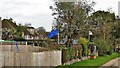
Are they on speaking terms, I wonder?
These houses have been displaying flags for quite some time - possibly since 2016. I took this photograph after 31 Jan 2020, and a couple of changes were evident compared with the previous time I looked: (1) the EU flag is at half-mast; (2) an England flag has replaced the Union flag that was there before. Given that this area was split more or less 50:50 on the Brexit issue, it could be argued that this is a politically representative image for this square!
Image: © Ian Hawfinch
Taken: 14 Feb 2020
0.02 miles
2
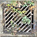
Drain cover by the A2037
Jeremy Corbyn goes around photographing these if I'm not mistaken. I wonder if he's got this one? To be fair, I actually think they make quite good subjects.
Image: © Ian Hawfinch
Taken: 23 Sep 2020
0.06 miles
4
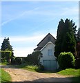
Mill House (2), Henfield Common South, Henfield
The larger building was built as a steam mill during the 1870s and operated until around 1909 and is located to the immediate south of Image It was probably built to replace Image which was located to the immediate east.
Image: © Simon Carey
Taken: 21 May 2017
0.06 miles
5
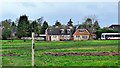
Houses on the south side of Henfield Common
The number 17 bus to Brighton has entered on the right of the shot.
Image: © Ian Hawfinch
Taken: 13 Feb 2020
0.07 miles
6
Mill House (1), Henfield Common South, Henfield
The house was built in the latter part of the 19th century and is located to the rear of Image which had been built as a steam mill probably to replace Image which was located to its immediate east.
Image: © Simon Carey
Taken: 21 May 2017
0.08 miles
7

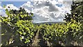
Vine leaves on The Lydds
There is a micro-vineyard on this part of the south-facing slope known as "The Lydds". The land hereabouts was formerly used for market gardening - and could probably support more vineyards.
Image: © Ian Hawfinch
Taken: 26 Oct 2022
0.08 miles
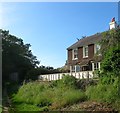
8
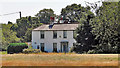
April Cottage/The White House, Brighton Road, Henfield
Located on the southern side of Henfield Common it was built as a single dwelling in the early 19th century and was known as Clifton House. The White House is on the right with the door facing the camera whilst April Cottage is on the left whose door faces east. The latter was also known as Clifton Cottage.
Image: © Simon Carey
Taken: 21 May 2017
0.08 miles
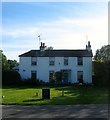
9
House on the south side of Henfield Common
The light and the colour of the grass suggest summer heat and, indeed, the temperature was 32 C.
Image: © Ian Hawfinch
Taken: 25 Jun 2020
0.08 miles