IMAGES TAKEN NEAR TO
Alma Terrace, HENFIELD, BN5 9DR
Introduction
This page details the photographs taken nearby to Alma Terrace, BN5 9DR by members of the Geograph project.
The Geograph project started in 2005 with the aim of publishing, organising and preserving representative images for every square kilometre of Great Britain, Ireland and the Isle of Man.

There are currently over 7.5m images from over14,400 individuals and you can help contribute to the project by visiting https://www.geograph.org.uk
Image Map
Images are licensed for reuse under creativecommons.org/licenses/by-sa/2.0
Notes
- Clicking on the map will re-center to the selected point.
- The higher the marker number, the further away the image location is from the centre of the postcode.
Image Listing (320 Images Found)
Images are licensed for reuse under creativecommons.org/licenses/by-sa/2.0
Image
Details
Distance
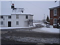
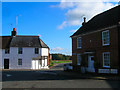
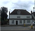
2
Alma Cottages, Brighton Road, Henfield
A small terrace of four cottages built in the 1850s at the western end of Brighton Road prior to its junction with Golden Square. Beyond the cottages is Henfield Common.
Image: © Simon Carey
Taken: 21 May 2017
0.00 miles
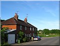
3
Houses at the west end of Henfield Common
The road in front of the houses is the A281.
Image: © Ian Hawfinch
Taken: 13 Mar 2020
0.00 miles
4
Houses at the west end of Henfield Common
Image: © Ian Hawfinch
Taken: 13 Feb 2020
0.01 miles
5
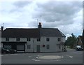
Golden Square
A familiar sight to anyone travelling through Henfield as the A281 meets the A2037. The earliest route through Henfield was the north-south one linking the port of Shoreham with Horsham and eventually London, the growth of Brighton in the late 18th century meant the coaching route linked up with this existing route via the Devil's Dyke and Woodmancote and Henfield remained a coaching stop until other more direct routes between London and Brighton came into existence. The houses on the left date from the 17th and 18th century whilst the greenery down Brighton Road is Henfield Common.
Image: © Simon Carey
Taken: 28 Oct 2008
0.02 miles
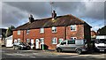
6
The Golden Hen/Challens, Golden Square, Henfield
Challens is the building on the right adjacent to Brighton Road whilst The Golden Hen is to the left and contains a former shop front. Both buildings date back to the 18th century and I believe the posts and overhang on Challens were added sometime in the past to enable better access for vehicles turning into the road.
Image: © Simon Carey
Taken: 23 Jul 2017
0.02 miles
7

House on Golden Square
Part of the upper storey is supported by pillars.
Image: © Ian Hawfinch
Taken: 13 Mar 2020
0.02 miles
8
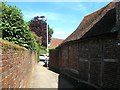
Twitten, Henfield
Connecting Golden Square to Henfield Common. The timber framing on the right belongs to Forges which dates back to the 18th century.
Image: © Simon Carey
Taken: 21 May 2017
0.02 miles
9
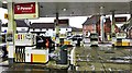
Henfield, Sussex - Golden Square viewed from the Shell petrol station
Image: © Ian Hawfinch
Taken: 9 Feb 2020
0.02 miles
10
Forges/Part Forges, Golden Square, Henfield
Dating back to at least the 18th century but may be older. The path on the left leads to Henfield Common.
Image: © Simon Carey
Taken: 23 Jul 2017
0.02 miles