IMAGES TAKEN NEAR TO
Wheatsheaf Road, HENFIELD, BN5 9BL
Introduction
This page details the photographs taken nearby to Wheatsheaf Road, BN5 9BL by members of the Geograph project.
The Geograph project started in 2005 with the aim of publishing, organising and preserving representative images for every square kilometre of Great Britain, Ireland and the Isle of Man.

There are currently over 7.5m images from over14,400 individuals and you can help contribute to the project by visiting https://www.geograph.org.uk
Image Map
Images are licensed for reuse under creativecommons.org/licenses/by-sa/2.0
Notes
- Clicking on the map will re-center to the selected point.
- The higher the marker number, the further away the image location is from the centre of the postcode.
Image Listing (26 Images Found)
Images are licensed for reuse under creativecommons.org/licenses/by-sa/2.0
Image
Details
Distance
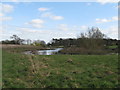
1
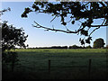
Cart House Field
The name of the field according to the 1840 tithe map and taken from the water meadow lying next to the River Adur.
Image: © Simon Carey
Taken: 18 Sep 2010
0.08 miles
2
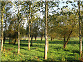
Boggy Ground
Near to the River Adur seemingly being guarded by the surrounding trees.
Image: © Simon Carey
Taken: 18 Sep 2010
0.12 miles
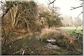
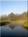
3
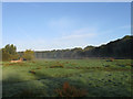
North Brook
The name of the field according to the 1840 tithe map. The mist can still be seen riding from the neighbouring River Adur.
Image: © Simon Carey
Taken: 18 Sep 2010
0.13 miles
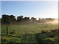
4
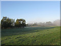
West Middle Brook (2)
The name of the field according to the 1840 tithe map. An early morning light frost covers the grass whilst the mist is rising from the river beyond the embankment to the right.
Image: © Simon Carey
Taken: 18 Sep 2010
0.13 miles
5
Island on riverside pool
Part of the Adur floodplain
Image: © Dave Spicer
Taken: 22 Mar 2009
0.16 miles
6
West Middle Brook (1)
The name of the field according to the 1840 tithe map with the early morning mist rising off the River Adur to the left.
Image: © Simon Carey
Taken: 18 Sep 2010
0.17 miles
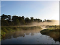
7
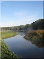
River Adur
The eastern arm of the river that rises on Ditchling Common and joins the western branch north-west of Henfield. The mist seems to be hitting the northern then rising up in wisps. Stone Croft Wood is on the right.
Image: © Simon Carey
Taken: 18 Sep 2010
0.18 miles
8
Wineham canal
A short section of the old canal still with water. This was a short canal allowing barges to reach Wineham from the river Adur
Image: © Peter Jeffery
Taken: 1 Mar 1998
0.20 miles
9
River Adur
Looking towards a sluice gate as the mist rises from the river. This is the eastern arm that rises on Ditchling Common and joins the western branch north-west of Henfield.
Image: © Simon Carey
Taken: 18 Sep 2010
0.20 miles
10
River Adur
Opposite view of Image with the mist rising off the water and being turned a shade of crimson by the early morning sun.
Image: © Simon Carey
Taken: 18 Sep 2010
0.20 miles