IMAGES TAKEN NEAR TO
School Lane, BRIGHTON, BN45 7FQ
Introduction
This page details the photographs taken nearby to School Lane, BN45 7FQ by members of the Geograph project.
The Geograph project started in 2005 with the aim of publishing, organising and preserving representative images for every square kilometre of Great Britain, Ireland and the Isle of Man.

There are currently over 7.5m images from over14,400 individuals and you can help contribute to the project by visiting https://www.geograph.org.uk
Image Map
Images are licensed for reuse under creativecommons.org/licenses/by-sa/2.0
Notes
- Clicking on the map will re-center to the selected point.
- The higher the marker number, the further away the image location is from the centre of the postcode.
Image Listing (170 Images Found)
Images are licensed for reuse under creativecommons.org/licenses/by-sa/2.0
Image
Details
Distance
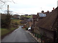
1
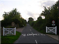
School Lane
Opposite view of Image taking local vehicular traffic and the South Downs Way into the village of Pyecombe from the A273.
Image: © Simon Carey
Taken: 22 Aug 2008
0.03 miles
2
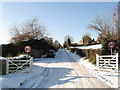
School Lane
A snowy view of Image where in the intervening 14 months the width road signs have been replaced by 20mph speed limit ones. As well as being the access point for the village from the A273 the lane is also part of the South Downs Way.
Image: © Simon Carey
Taken: 20 Dec 2009
0.03 miles
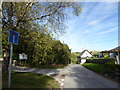
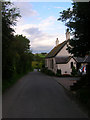
5
School Lane, Pyecombe
A view down School Lane in the village of Pyecombe, in the South Downs.
This lane forms part of National Cycle Network route 20, as well as the South Downs Way.
Image: © Malc McDonald
Taken: 8 Jan 2017
0.05 miles
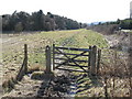
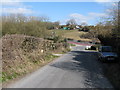
7
Old School Cottage, School Lane
The old 19th century school just off the crossroads at the centre. The lane leads down to the A273. Beyond is Pyecombe Golf Course.
Image: © Simon Carey
Taken: 22 Aug 2008
0.05 miles
8
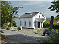
Former Congregational Chapel, Pyecombe
Image: © Robin Webster
Taken: 25 May 2019
0.05 miles
9
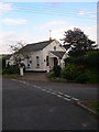
The Chapel, School Lane
At the crossroads in the centre of the village. Former 19th century chapel now converted into a residence.
Image: © Simon Carey
Taken: 22 Aug 2008
0.06 miles
10
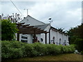
Converted chapel at Pyecombe
This building is on the South Downs Way National Trail.
Image: © Shazz
Taken: 27 May 2011
0.06 miles